Trenčianske Teplice geodata
Trenčianske Teplice (Trenčiansky kraj) is a populated place; located in Slovakia in Europe/Bratislava (GMT+2) time zone. With population of 4,438 people, there are 117 cities with bigger population in this country. Compared to other cities in Slovakia, 60.6% of cities are located further ↓South; 74.1% of cities are located further →East and 50.6% of cities have higher elevation than Trenčianske Teplice. Note1
Administrative division(s):
- Level 1: Trenčiansky kraj
- Level 2: Okres Trenčín
- Level 3: Trenčianske Teplice


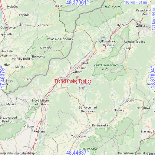
Trenčianske Teplice GPS coordinates[2]
48° 54' 38.268" North, 18° 10' 0.876" East
| Map corner | latitude | longitude |
|---|---|---|
| Upper-left | 49.37061°, | 17.46379° |
| Center: | 48.91063°, | 18.16691° |
| Lower-right: | 48.44637°, | 18.87004° |
| Map W x H: | 102.8×102.8 km | = 63.9×63.9mi |
| max Lat: | 49.43503° ⇑39.4% North |
| Trenčianske Teplice: | 48.91063° |
| min Lat: | ⇓60.6% South 47.76356° |
| min Long | Trenčianske Te | max Long |
| 16.9786° | 18.16691° | 22.18136° |
| W 25.9%⇐ | ⇒74.1% E |
Elevation
Elevation of Trenčianske Teplice is 267 m = 876 ft, and this is 69.1 m = 227 ft below average elevation for this country.
| Max E: |
1006 m = 3301 ft | 50.6% |
| Avg. | 336.1 m = 1103 ft | |
| Trenčianske Teplice | 267 m = 876 ft | |
Min E: |
102 m = 335 ft | 49.4% |
See also: Slovakia elevation on elevation.city.
Geographical zone
Trenčianske Teplice is located in North temperate zone (between Tropic of Cancer and the Arctic Circle). Distance of this North polar circle is 1962.8 km =1219.6 mi to North.| Distance of | km | miles | from Trenčianske Teplice |
|---|---|---|---|
| North Pole | 4568.7 | 2838.9 | to North |
| Arctic Circle | 1962.8 | 1219.6 | to North |
| Tropic Cancer | 2832.4 | 1760 | to South |
| Equator | 5438.4 | 3379.3 | to South |


Nearby cities:
15 places around Trenčianske Teplice: (largest is in red/bold)
• Bojnice
33.7 km =20.9 mi,  114°
114°
• Bánovce nad Bebravou
22.1 km =13.7 mi,  162°
162°
• Dubnica nad Váhom
5.5 km =3.4 mi,  359°
359°
• Ilava
10.9 km =6.8 mi,  27°
27°
• Nemšová
7.2 km =4.5 mi,  330°
330°
• Nová Dubnica
3.1 km =1.9 mi, 330°
• Nováky
34.8 km =21.6 mi,  129°
129°
• Nové Mesto nad Váhom
29.9 km =18.6 mi,  235°
235°
• Partizánske
35.2 km =21.9 mi,  153°
153°
• Považská Bystrica
29.9 km =18.6 mi,  38°
38°
• Prievidza
36.9 km =22.9 mi, 114°
• Púchov
26.5 km =16.5 mi, 25°
• Stará Turá
37.6 km =23.4 mi,  246°
246°
• Trenčín
9.1 km =5.7 mi,  258°
258°
• Čachtice
35.5 km =22.1 mi,  231°
231°
Sources, notices
• [Note1] Compared only with cities in Slovakia existing in our database
• [Src1] Map data: © OpenStreetMap contributors (CC-BY-SA)
• [Src2] Other city data from geonames.org with taken over terms of usage.
• [Src3] Geographical zone / Annual Mean Temperature by Robert A. Rohde @ Wikipedia
