Ilava geodata
Ilava (Trenčiansky kraj) is a seat of a second-order administrative division; located in Slovakia in Europe/Bratislava (GMT+2) time zone. With population of 5,411 people, there are 105 cities with bigger population in this country. Compared to other cities in Slovakia, 65.9% of cities are located further ↓South; 71.8% of cities are located further →East and 52.4% of cities have higher elevation than Ilava. Note1


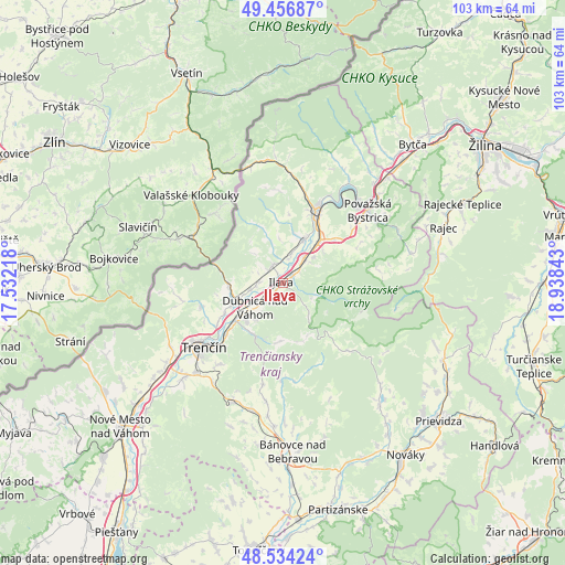
Ilava GPS coordinates[2]
48° 59' 51.684" North, 18° 14' 7.08" East
| Map corner | latitude | longitude |
|---|---|---|
| Upper-left | 49.45687°, | 17.53218° |
| Center: | 48.99769°, | 18.2353° |
| Lower-right: | 48.53424°, | 18.93843° |
| Map W x H: | 102.6×102.6 km | = 63.8×63.8mi |
| max Lat: | 49.43503° ⇑34.1% North |
| Ilava: | 48.99769° |
| min Lat: | ⇓65.9% South 47.76356° |
| min Long | Ilava | max Long |
| 16.9786° | 18.2353° | 22.18136° |
| W 28.2%⇐ | ⇒71.8% E |
Elevation
Elevation of Ilava is 258 m = 846 ft, and this is 78.1 m = 256 ft below average elevation for this country.
| Max E: |
1006 m = 3301 ft | 52.4% |
| Avg. | 336.1 m = 1103 ft | |
| Ilava | 258 m = 846 ft | |
Min E: |
102 m = 335 ft | 47.6% |
See also: Slovakia elevation on elevation.city.
Geographical zone
Ilava is located in North temperate zone (between Tropic of Cancer and the Arctic Circle). Distance of this North polar circle is 1953.1 km =1213.6 mi to North.| Distance of | km | miles | from Ilava |
|---|---|---|---|
| North Pole | 4559 | 2832.8 | to North |
| Arctic Circle | 1953.1 | 1213.6 | to North |
| Tropic Cancer | 2842.1 | 1766 | to South |
| Equator | 5448 | 3385.2 | to South |


Nearby cities:
15 places around Ilava: (largest is in red/bold)
• Bojnice
34.9 km =21.7 mi,  132°
132°
• Bytča
34.5 km =21.4 mi,  43°
43°
• Bánovce nad Bebravou
30.8 km =19.1 mi,  176°
176°
• Dubnica nad Váhom
6.6 km =4.1 mi,  230°
230°
• Nemšová
9.2 km =5.7 mi,  248°
248°
• Nová Dubnica
9.5 km =5.9 mi,  222°
222°
• Nováky
38.6 km =24 mi,  145°
145°
• Nové Mesto nad Váhom
39.8 km =24.7 mi, 227°
• Partizánske
42.5 km =26.4 mi,  165°
165°
• Považská Bystrica
19.3 km =12 mi, 44°
• Prievidza
37.9 km =23.5 mi, 130°
• Púchov
15.6 km =9.7 mi,  25°
25°
• Rajec
31.2 km =19.4 mi,  71°
71°
• Trenčianske Teplice
10.9 km =6.8 mi,  207°
207°
• Trenčín
18.1 km =11.2 mi, 230°
Sources, notices
• [Note1] Compared only with cities in Slovakia existing in our database
• [Src1] Map data: © OpenStreetMap contributors (CC-BY-SA)
• [Src2] Other city data from geonames.org with taken over terms of usage.
• [Src3] Geographical zone / Annual Mean Temperature by Robert A. Rohde @ Wikipedia
