Skalica geodata
Skalica (Trnavský kraj) is a seat of a second-order administrative division; located in Slovakia in Europe/Bratislava (GMT+2) time zone. With population of 15,013 people, there are 51 cities with bigger population in this country. Compared to other cities in Slovakia, 55.9% of cities are located further ↓South; 94.7% of cities are located further →East and 72.4% of cities have higher elevation than Skalica. Note1


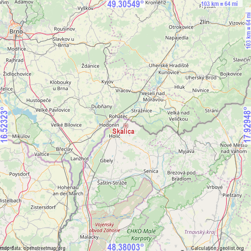
Skalica GPS coordinates[2]
48° 50' 41.64" North, 17° 13' 34.86" East
| Map corner | latitude | longitude |
|---|---|---|
| Upper-left | 49.30549°, | 16.52323° |
| Center: | 48.8449°, | 17.22635° |
| Lower-right: | 48.38003°, | 17.92948° |
| Map W x H: | 102.9×102.9 km | = 63.9×63.9mi |
| max Lat: | 49.43503° ⇑44.1% North |
| Skalica: | 48.8449° |
| min Lat: | ⇓55.9% South 47.76356° |
| min Long | Skalica | max Long |
| 16.9786° | 17.22635° | 22.18136° |
| W 5.3%⇐ | ⇒94.7% E |
Elevation
Elevation of Skalica is 179 m = 587 ft, and this is 157.1 m = 515 ft below average elevation for this country.
| Max E: |
1006 m = 3301 ft | 72.4% |
| Avg. | 336.1 m = 1103 ft | |
| Skalica | 179 m = 587 ft | |
Min E: |
102 m = 335 ft | 27.6% |
See also: Slovakia elevation on elevation.city.
Geographical zone
Skalica is located in North temperate zone (between Tropic of Cancer and the Arctic Circle). Distance of this North polar circle is 1970.1 km =1224.2 mi to North.| Distance of | km | miles | from Skalica |
|---|---|---|---|
| North Pole | 4576 | 2843.4 | to North |
| Arctic Circle | 1970.1 | 1224.2 | to North |
| Tropic Cancer | 2825.1 | 1755.4 | to South |
| Equator | 5431 | 3374.7 | to South |


Nearby cities:
15 places around Skalica: (largest is in red/bold)
• Brezová pod Bradlom
30.5 km =19 mi,  131°
131°
• Gbely
16.3 km =10.1 mi,  209°
209°
• Holíč
6 km =3.7 mi,  231°
231°
• Leopoldov
59.4 km =36.9 mi,  138°
138°
• Malacky
47.9 km =29.8 mi,  198°
198°
• Modra
57.1 km =35.5 mi,  174°
174°
• Myjava
26.8 km =16.7 mi,  110°
110°
• Nové Mesto nad Váhom
45.3 km =28.1 mi,  102°
102°
• Piešťany
52 km =32.3 mi,  122°
122°
• Senica
21.1 km =13.1 mi,  150°
150°
• Smolenice
40.7 km =25.3 mi,  158°
158°
• Stará Turá
35.1 km =21.8 mi, 102°
• Trnava
58.4 km =36.3 mi, 152°
• Vrbové
44.2 km =27.5 mi, 124°
• Čachtice
43.6 km =27.1 mi, 109°
Sources, notices
• [Note1] Compared only with cities in Slovakia existing in our database
• [Src1] Map data: © OpenStreetMap contributors (CC-BY-SA)
• [Src2] Other city data from geonames.org with taken over terms of usage.
• [Src3] Geographical zone / Annual Mean Temperature by Robert A. Rohde @ Wikipedia
