Myjava geodata
Myjava (Trenčiansky kraj) is a populated place; located in Slovakia in Europe/Bratislava (GMT+2) time zone. With population of 13,142 people, there are 55 cities with bigger population in this country. Compared to other cities in Slovakia, 50.6% of cities are located further ↓South; 88.2% of cities are located further →East and 59.4% of cities have lower elevation than Myjava. Note1


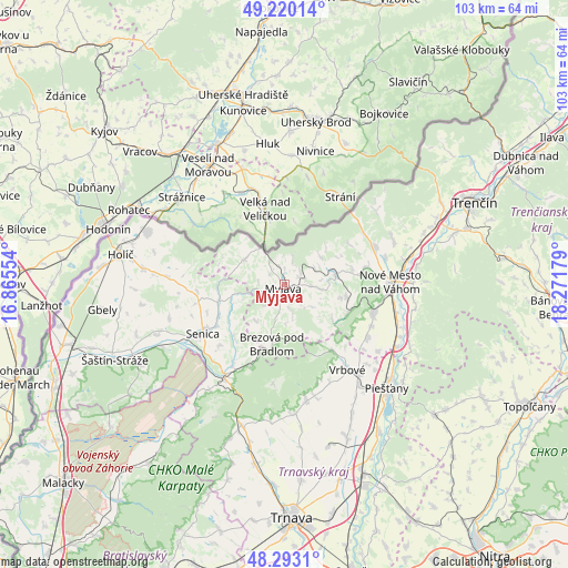
Myjava GPS coordinates[2]
48° 45' 31.536" North, 17° 34' 7.176" East
| Map corner | latitude | longitude |
|---|---|---|
| Upper-left | 49.22014°, | 16.86554° |
| Center: | 48.75876°, | 17.56866° |
| Lower-right: | 48.2931°, | 18.27179° |
| Map W x H: | 103.1×103.1 km | = 64.1×64.1mi |
| max Lat: | 49.43503° ⇑49.4% North |
| Myjava: | 48.75876° |
| min Lat: | ⇓50.6% South 47.76356° |
| min Long | Myjava | max Long |
| 16.9786° | 17.56866° | 22.18136° |
| W 11.8%⇐ | ⇒88.2% E |
Elevation
Elevation of Myjava is 332 m = 1089 ft, and this is 4.1 m = 13 ft below average elevation for this country.
| Max E: |
1006 m = 3301 ft | 40.6% |
| Avg. | 336.1 m = 1103 ft | |
| Myjava | 332 m = 1089 ft | |
Min E: |
102 m = 335 ft | 59.4% |
See also: Slovakia elevation on elevation.city.
Geographical zone
Myjava is located in North temperate zone (between Tropic of Cancer and the Arctic Circle). Distance of this North polar circle is 1979.7 km =1230.1 mi to North.| Distance of | km | miles | from Myjava |
|---|---|---|---|
| North Pole | 4585.6 | 2849.4 | to North |
| Arctic Circle | 1979.7 | 1230.1 | to North |
| Tropic Cancer | 2815.5 | 1749.5 | to South |
| Equator | 5421.5 | 3368.8 | to South |


Nearby cities:
15 places around Myjava: (largest is in red/bold)
• Brezová pod Bradlom
10.8 km =6.7 mi,  191°
191°
• Gbely
33.5 km =20.8 mi,  262°
262°
• Hlohovec
40.2 km =25 mi,  154°
154°
• Holíč
30.3 km =18.8 mi,  281°
281°
• Leopoldov
37.7 km =23.4 mi,  157°
157°
• Nové Mesto nad Váhom
19.2 km =11.9 mi,  90°
90°
• Piešťany
26.3 km =16.3 mi,  133°
133°
• Senica
17.2 km =10.7 mi,  239°
239°
• Skalica
26.8 km =16.7 mi,  290°
290°
• Smolenice
30 km =18.6 mi,  199°
199°
• Stará Turá
9.4 km =5.8 mi,  77°
77°
• Trenčín
38 km =23.6 mi,  66°
66°
• Trnava
42.4 km =26.3 mi,  178°
178°
• Vrbové
19.1 km =11.9 mi,  143°
143°
• Čachtice
16.8 km =10.4 mi,  107°
107°
Sources, notices
• [Note1] Compared only with cities in Slovakia existing in our database
• [Src1] Map data: © OpenStreetMap contributors (CC-BY-SA)
• [Src2] Other city data from geonames.org with taken over terms of usage.
• [Src3] Geographical zone / Annual Mean Temperature by Robert A. Rohde @ Wikipedia
