Vinné geodata
Vinné (Košický kraj) is a populated place; located in Slovakia in Europe/Bratislava (GMT+2) time zone. With population of 1,608 people, there are 138 cities with bigger population in this country. Compared to other cities in Slovakia, 54.1% of cities are located further ↓South; 98.2% of cities are located further ←West and 80% of cities have higher elevation than Vinné. Note1


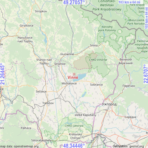
Vinné GPS coordinates[2]
48° 48' 34.74" North, 21° 58' 3.252" East
| Map corner | latitude | longitude |
|---|---|---|
| Upper-left | 49.27057°, | 21.26445° |
| Center: | 48.80965°, | 21.96757° |
| Lower-right: | 48.34446°, | 22.6707° |
| Map W x H: | 103×103 km | = 64×64mi |
| max Lat: | 49.43503° ⇑45.9% North |
| Vinné: | 48.80965° |
| min Lat: | ⇓54.1% South 47.76356° |
| min Long | Vinné | max Long |
| 16.9786° | 21.96757° | 22.18136° |
| W 98.2%⇐ | ⇒1.8% E |
Elevation
Elevation of Vinné is 150 m = 492 ft, and this is 186.1 m = 611 ft below average elevation for this country.
| Max E: |
1006 m = 3301 ft | 80% |
| Avg. | 336.1 m = 1103 ft | |
| Vinné | 150 m = 492 ft | |
Min E: |
102 m = 335 ft | 20% |
See also: Slovakia elevation on elevation.city.
Geographical zone
Vinné is located in North temperate zone (between Tropic of Cancer and the Arctic Circle). Distance of this North polar circle is 1974 km =1226.6 mi to North.| Distance of | km | miles | from Vinné |
|---|---|---|---|
| North Pole | 4579.9 | 2845.8 | to North |
| Arctic Circle | 1974 | 1226.6 | to North |
| Tropic Cancer | 2821.2 | 1753 | to South |
| Equator | 5427.1 | 3372.2 | to South |


Nearby cities:
15 places around Vinné: (largest is in red/bold)
• Chlmec
8.8 km =5.5 mi,  346°
346°
• Giraltovce
47.2 km =29.3 mi,  315°
315°
• Humenné
14.7 km =9.1 mi, 345°
• Kavečany
55.9 km =34.7 mi,  266°
266°
• Košice
53.1 km =33 mi,  258°
258°
• Medzilaborce
51.6 km =32.1 mi, 354°
• Michalovce
7.1 km =4.4 mi,  209°
209°
• Sečovce
25.5 km =15.8 mi,  241°
241°
• Snina
24 km =14.9 mi,  33°
33°
• Sobrance
17.3 km =10.7 mi,  114°
114°
• Stropkov
49.3 km =30.6 mi,  332°
332°
• Strážske
11.9 km =7.4 mi,  306°
306°
• Trebišov
27.1 km =16.8 mi,  222°
222°
• Vranov nad Topľou
22.5 km =14 mi,  292°
292°
• Čierna nad Tisou
44.6 km =27.7 mi,  168°
168°
Sources, notices
• [Note1] Compared only with cities in Slovakia existing in our database
• [Src1] Map data: © OpenStreetMap contributors (CC-BY-SA)
• [Src2] Other city data from geonames.org with taken over terms of usage.
• [Src3] Geographical zone / Annual Mean Temperature by Robert A. Rohde @ Wikipedia
