Giraltovce geodata
Giraltovce (Prešovský kraj) is a populated place; located in Slovakia in Europe/Bratislava (GMT+2) time zone. With population of 4,189 people, there are 121 cities with bigger population in this country. Compared to other cities in Slovakia, 77.6% of cities are located further ↓South; 91.8% of cities are located further ←West and 68.2% of cities have higher elevation than Giraltovce. Note1


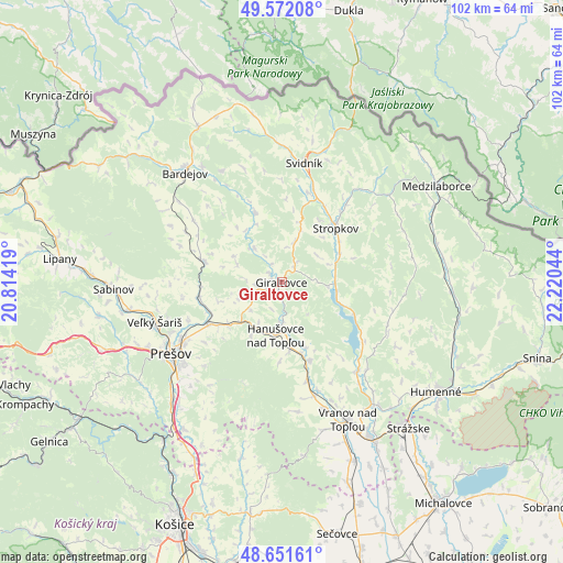
Giraltovce GPS coordinates[2]
49° 6' 50.328" North, 21° 31' 2.316" East
| Map corner | latitude | longitude |
|---|---|---|
| Upper-left | 49.57208°, | 20.81419° |
| Center: | 49.11398°, | 21.51731° |
| Lower-right: | 48.65161°, | 22.22044° |
| Map W x H: | 102.3×102.3 km | = 63.6×63.6mi |
| max Lat: | 49.43503° ⇑22.4% North |
| Giraltovce: | 49.11398° |
| min Lat: | ⇓77.6% South 47.76356° |
| min Long | Giraltovce | max Long |
| 16.9786° | 21.51731° | 22.18136° |
| W 91.8%⇐ | ⇒8.2% E |
Elevation
Elevation of Giraltovce is 189 m = 620 ft, and this is 147.1 m = 483 ft below average elevation for this country.
| Max E: |
1006 m = 3301 ft | 68.2% |
| Avg. | 336.1 m = 1103 ft | |
| Giraltovce | 189 m = 620 ft | |
Min E: |
102 m = 335 ft | 31.8% |
See also: Slovakia elevation on elevation.city.
Geographical zone
Giraltovce is located in North temperate zone (between Tropic of Cancer and the Arctic Circle). Distance of this North polar circle is 1940.2 km =1205.6 mi to North.| Distance of | km | miles | from Giraltovce |
|---|---|---|---|
| North Pole | 4546.1 | 2824.8 | to North |
| Arctic Circle | 1940.2 | 1205.6 | to North |
| Tropic Cancer | 2855 | 1774 | to South |
| Equator | 5461 | 3393.3 | to South |


Nearby cities:
15 places around Giraltovce: (largest is in red/bold)
• Bardejov
26.6 km =16.5 mi,  318°
318°
• Chlmec
39.9 km =24.8 mi,  129°
129°
• Humenné
35.1 km =21.8 mi,  124°
124°
• Kavečany
43.9 km =27.3 mi,  211°
211°
• Lipany
40.5 km =25.2 mi,  276°
276°
• Medzilaborce
32.9 km =20.4 mi,  57°
57°
• Prešov
24.3 km =15.1 mi,  238°
238°
• Sabinov
30.5 km =19 mi,  267°
267°
• Sečovce
47.1 km =29.3 mi,  167°
167°
• Snina
48.2 km =30 mi,  106°
106°
• Stropkov
13.9 km =8.6 mi,  45°
45°
• Strážske
35.5 km =22.1 mi,  138°
138°
• Svidník
21.9 km =13.6 mi,  10°
10°
• Vinné
47.2 km =29.3 mi, 135°
• Vranov nad Topľou
27.9 km =17.3 mi,  154°
154°
Sources, notices
• [Note1] Compared only with cities in Slovakia existing in our database
• [Src1] Map data: © OpenStreetMap contributors (CC-BY-SA)
• [Src2] Other city data from geonames.org with taken over terms of usage.
• [Src3] Geographical zone / Annual Mean Temperature by Robert A. Rohde @ Wikipedia
