Humenné geodata
Humenné (Prešovský kraj) is a seat of a second-order administrative division; located in Slovakia in Europe/Bratislava (GMT+2) time zone. With population of 35,367 people, there are 18 cities with bigger population in this country. Compared to other cities in Slovakia, 62.4% of cities are located further ↓South; 96.5% of cities are located further ←West and 79.4% of cities have higher elevation than Humenné. Note1


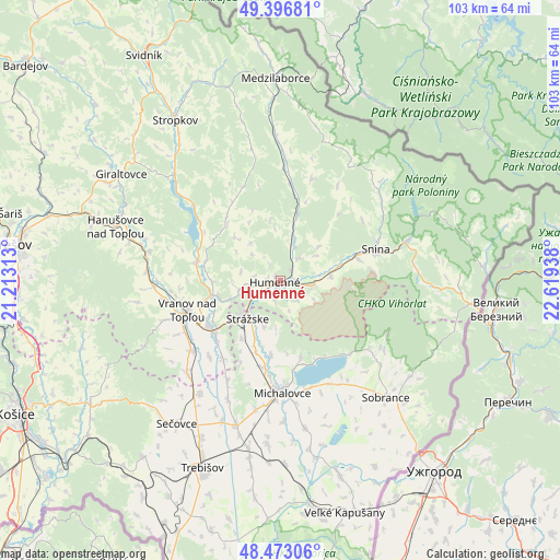
Humenné GPS coordinates[2]
48° 56' 13.452" North, 21° 54' 58.5" East
| Map corner | latitude | longitude |
|---|---|---|
| Upper-left | 49.39681°, | 21.21313° |
| Center: | 48.93707°, | 21.91625° |
| Lower-right: | 48.47306°, | 22.61938° |
| Map W x H: | 102.7×102.7 km | = 63.8×63.8mi |
| max Lat: | 49.43503° ⇑37.6% North |
| Humenné: | 48.93707° |
| min Lat: | ⇓62.4% South 47.76356° |
| min Long | Humenné | max Long |
| 16.9786° | 21.91625° | 22.18136° |
| W 96.5%⇐ | ⇒3.5% E |
Elevation
Elevation of Humenné is 152 m = 499 ft, and this is 184.1 m = 604 ft below average elevation for this country.
| Max E: |
1006 m = 3301 ft | 79.4% |
| Avg. | 336.1 m = 1103 ft | |
| Humenné | 152 m = 499 ft | |
Min E: |
102 m = 335 ft | 20.6% |
See also: Slovakia elevation on elevation.city.
Geographical zone
Humenné is located in North temperate zone (between Tropic of Cancer and the Arctic Circle). Distance of this North polar circle is 1959.9 km =1217.8 mi to North.| Distance of | km | miles | from Humenné |
|---|---|---|---|
| North Pole | 4565.8 | 2837.1 | to North |
| Arctic Circle | 1959.9 | 1217.8 | to North |
| Tropic Cancer | 2835.4 | 1761.8 | to South |
| Equator | 5441.3 | 3381.1 | to South |


Nearby cities:
15 places around Humenné: (largest is in red/bold)
• Chlmec
5.9 km =3.7 mi,  163°
163°
• Giraltovce
35.1 km =21.8 mi,  304°
304°
• Košice
54.2 km =33.7 mi,  242°
242°
• Medzilaborce
37.3 km =23.2 mi,  358°
358°
• Michalovce
20.3 km =12.6 mi,  179°
179°
• Prešov
50.3 km =31.3 mi,  277°
277°
• Sečovce
32.2 km =20 mi,  215°
215°
• Snina
18.1 km =11.2 mi,  71°
71°
• Sobrance
28.9 km =18 mi,  137°
137°
• Stropkov
35.2 km =21.9 mi,  326°
326°
• Strážske
9.2 km =5.7 mi, 219°
• Svidník
48.3 km =30 mi, 328°
• Trebišov
37.2 km =23.1 mi,  202°
202°
• Vinné
14.7 km =9.1 mi,  165°
165°
• Vranov nad Topľou
17.8 km =11.1 mi,  252°
252°
Sources, notices
• [Note1] Compared only with cities in Slovakia existing in our database
• [Src1] Map data: © OpenStreetMap contributors (CC-BY-SA)
• [Src2] Other city data from geonames.org with taken over terms of usage.
• [Src3] Geographical zone / Annual Mean Temperature by Robert A. Rohde @ Wikipedia
