Sečovce geodata
Sečovce (Košický kraj) is a populated place; located in Slovakia in Europe/Bratislava (GMT+2) time zone. With population of 7,819 people, there are 84 cities with bigger population in this country. Compared to other cities in Slovakia, 57.6% of cities are located further ↑North; 93.5% of cities are located further ←West and 90% of cities have higher elevation than Sečovce. Note1


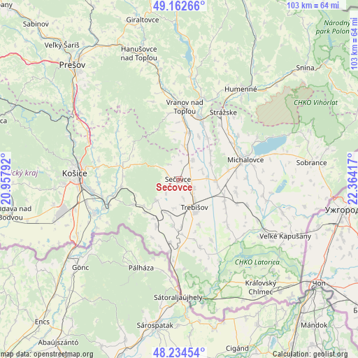
Sečovce GPS coordinates[2]
48° 42' 2.664" North, 21° 39' 39.744" East
| Map corner | latitude | longitude |
|---|---|---|
| Upper-left | 49.16266°, | 20.95792° |
| Center: | 48.70074°, | 21.66104° |
| Lower-right: | 48.23454°, | 22.36417° |
| Map W x H: | 103.2×103.2 km | = 64.1×64.1mi |
| max Lat: | 49.43503° ⇑57.6% North |
| Sečovce: | 48.70074° |
| min Lat: | ⇓42.4% South 47.76356° |
| min Long | Sečovce | max Long |
| 16.9786° | 21.66104° | 22.18136° |
| W 93.5%⇐ | ⇒6.5% E |
Elevation
Elevation of Sečovce is 125 m = 410 ft, and this is 211.1 m = 693 ft below average elevation for this country.
| Max E: |
1006 m = 3301 ft | 90% |
| Avg. | 336.1 m = 1103 ft | |
| Sečovce | 125 m = 410 ft | |
Min E: |
102 m = 335 ft | 10% |
See also: Slovakia elevation on elevation.city.
Geographical zone
Sečovce is located in North temperate zone (between Tropic of Cancer and the Arctic Circle). Distance of this North polar circle is 1986.2 km =1234.2 mi to North.| Distance of | km | miles | from Sečovce |
|---|---|---|---|
| North Pole | 4592 | 2853.3 | to North |
| Arctic Circle | 1986.2 | 1234.2 | to North |
| Tropic Cancer | 2809.1 | 1745.5 | to South |
| Equator | 5415 | 3364.7 | to South |


Nearby cities:
15 places around Sečovce: (largest is in red/bold)
• Chlmec
29 km =18 mi,  44°
44°
• Giraltovce
47.1 km =29.3 mi,  347°
347°
• Humenné
32.2 km =20 mi, 35°
• Kavečany
34.4 km =21.4 mi,  284°
284°
• Košice
29.6 km =18.4 mi,  272°
272°
• Michalovce
19.9 km =12.4 mi,  72°
72°
• Moldava nad Bodvou
49.5 km =30.8 mi,  258°
258°
• Prešov
45.5 km =28.3 mi,  316°
316°
• Snina
48.1 km =29.9 mi,  48°
48°
• Sobrance
38.5 km =23.9 mi,  82°
82°
• Strážske
23.1 km =14.4 mi,  33°
33°
• Trebišov
9.1 km =5.7 mi,  151°
151°
• Vinné
25.5 km =15.8 mi,  61°
61°
• Vranov nad Topľou
20.9 km =13 mi,  4°
4°
• Čierna nad Tisou
44.6 km =27.7 mi,  135°
135°
Sources, notices
• [Note1] Compared only with cities in Slovakia existing in our database
• [Src1] Map data: © OpenStreetMap contributors (CC-BY-SA)
• [Src2] Other city data from geonames.org with taken over terms of usage.
• [Src3] Geographical zone / Annual Mean Temperature by Robert A. Rohde @ Wikipedia
