Snina geodata
Snina (Prešovský kraj) is a seat of a second-order administrative division; located in Slovakia in Europe/Bratislava (GMT+2) time zone. With population of 22,221 people, there are 33 cities with bigger population in this country. Compared to other cities in Slovakia, 65.3% of cities are located further ↓South; 99.4% of cities are located further ←West and 61.2% of cities have higher elevation than Snina. Note1


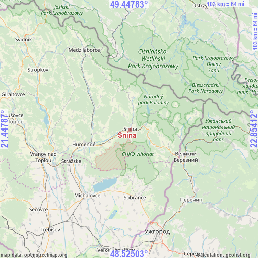
Snina GPS coordinates[2]
48° 59' 18.852" North, 22° 9' 3.564" East
| Map corner | latitude | longitude |
|---|---|---|
| Upper-left | 49.44783°, | 21.44787° |
| Center: | 48.98857°, | 22.15099° |
| Lower-right: | 48.52503°, | 22.85412° |
| Map W x H: | 102.6×102.6 km | = 63.8×63.8mi |
| max Lat: | 49.43503° ⇑34.7% North |
| Snina: | 48.98857° |
| min Lat: | ⇓65.3% South 47.76356° |
| min Long | Snina | max Long |
| 16.9786° | 22.15099° | 22.18136° |
| W 99.4%⇐ | ⇒0.59999999999999% E |
Elevation
Elevation of Snina is 215 m = 705 ft, and this is 121.1 m = 397 ft below average elevation for this country.
| Max E: |
1006 m = 3301 ft | 61.2% |
| Avg. | 336.1 m = 1103 ft | |
| Snina | 215 m = 705 ft | |
Min E: |
102 m = 335 ft | 38.8% |
See also: Slovakia elevation on elevation.city.
Geographical zone
Snina is located in North temperate zone (between Tropic of Cancer and the Arctic Circle). Distance of this North polar circle is 1954.2 km =1214.3 mi to North.| Distance of | km | miles | from Snina |
|---|---|---|---|
| North Pole | 4560 | 2833.5 | to North |
| Arctic Circle | 1954.2 | 1214.3 | to North |
| Tropic Cancer | 2841.1 | 1765.4 | to South |
| Equator | 5447 | 3384.6 | to South |


Nearby cities:
15 places around Snina: (largest is in red/bold)
• Chlmec
19.2 km =11.9 mi,  233°
233°
• Giraltovce
48.2 km =30 mi,  286°
286°
• Humenné
18.1 km =11.2 mi,  251°
251°
• Medzilaborce
36.4 km =22.6 mi,  329°
329°
• Michalovce
31.1 km =19.3 mi,  213°
213°
• Prešov
66.9 km =41.6 mi,  270°
270°
• Sečovce
48.1 km =29.9 mi, 228°
• Sobrance
27.2 km =16.9 mi,  175°
175°
• Stropkov
43.4 km =27 mi,  303°
303°
• Strážske
26.3 km =16.3 mi,  240°
240°
• Svidník
55.2 km =34.3 mi,  310°
310°
• Trebišov
51 km =31.7 mi,  218°
218°
• Vinné
24 km =14.9 mi, 213°
• Vranov nad Topľou
35.8 km =22.2 mi, 251°
• Čierna nad Tisou
63.7 km =39.6 mi, 184°
Sources, notices
• [Note1] Compared only with cities in Slovakia existing in our database
• [Src1] Map data: © OpenStreetMap contributors (CC-BY-SA)
• [Src2] Other city data from geonames.org with taken over terms of usage.
• [Src3] Geographical zone / Annual Mean Temperature by Robert A. Rohde @ Wikipedia
