Sobrance geodata
Sobrance (Košický kraj) is a seat of a second-order administrative division; located in Slovakia in Europe/Bratislava (GMT+2) time zone. With population of 6,262 people, there are 95 cities with bigger population in this country. Compared to other cities in Slovakia, 51.8% of cities are located further ↑North; 100% of cities are located further ←West and 92.9% of cities have higher elevation than Sobrance. Note1


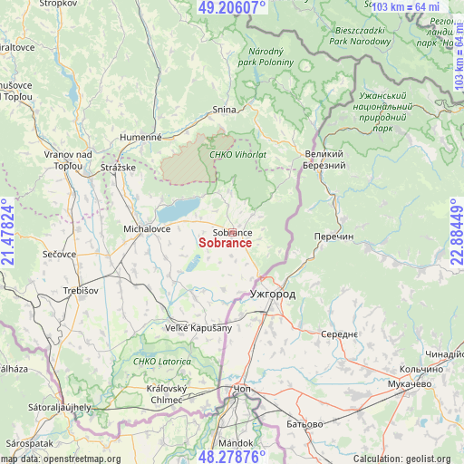
Sobrance GPS coordinates[2]
48° 44' 40.38" North, 22° 10' 52.896" East
| Map corner | latitude | longitude |
|---|---|---|
| Upper-left | 49.20607°, | 21.47824° |
| Center: | 48.74455°, | 22.18136° |
| Lower-right: | 48.27876°, | 22.88449° |
| Map W x H: | 103.1×103.1 km | = 64.1×64.1mi |
| max Lat: | 49.43503° ⇑51.8% North |
| Sobrance: | 48.74455° |
| min Lat: | ⇓48.2% South 47.76356° |
| min Long | Sobrance | max Long |
| 16.9786° | 22.18136° | 22.18136° |
| W 100%⇐ | ⇒0% E |
Elevation
Elevation of Sobrance is 118 m = 387 ft, and this is 218.1 m = 716 ft below average elevation for this country.
| Max E: |
1006 m = 3301 ft | 92.9% |
| Avg. | 336.1 m = 1103 ft | |
| Sobrance | 118 m = 387 ft | |
Min E: |
102 m = 335 ft | 7.1% |
See also: Slovakia elevation on elevation.city.
Geographical zone
Sobrance is located in North temperate zone (between Tropic of Cancer and the Arctic Circle). Distance of this North polar circle is 1981.3 km =1231.1 mi to North.| Distance of | km | miles | from Sobrance |
|---|---|---|---|
| North Pole | 4587.2 | 2850.4 | to North |
| Arctic Circle | 1981.3 | 1231.1 | to North |
| Tropic Cancer | 2814 | 1748.5 | to South |
| Equator | 5419.9 | 3367.8 | to South |


Nearby cities:
15 places around Sobrance: (largest is in red/bold)
• Chlmec
23.7 km =14.7 mi,  311°
311°
• Giraltovce
63.6 km =39.5 mi, 310°
• Humenné
28.9 km =18 mi,  317°
317°
• Kavečany
71.6 km =44.5 mi,  272°
272°
• Košice
67.8 km =42.1 mi, 267°
• Medzilaborce
62.1 km =38.6 mi,  340°
340°
• Michalovce
19.2 km =11.9 mi, 273°
• Sečovce
38.5 km =23.9 mi,  262°
262°
• Snina
27.2 km =16.9 mi,  355°
355°
• Stropkov
63.9 km =39.7 mi, 322°
• Strážske
29 km =18 mi,  299°
299°
• Trebišov
36.3 km =22.6 mi,  249°
249°
• Vinné
17.3 km =10.7 mi,  294°
294°
• Vranov nad Topľou
39.7 km =24.7 mi, 293°
• Čierna nad Tisou
37 km =23 mi,  190°
190°
Sources, notices
• [Note1] Compared only with cities in Slovakia existing in our database
• [Src1] Map data: © OpenStreetMap contributors (CC-BY-SA)
• [Src2] Other city data from geonames.org with taken over terms of usage.
• [Src3] Geographical zone / Annual Mean Temperature by Robert A. Rohde @ Wikipedia
