Strážske geodata
Strážske (Košický kraj) is a populated place; located in Slovakia in Europe/Bratislava (GMT+2) time zone. With population of 4,474 people, there are 116 cities with bigger population in this country. Compared to other cities in Slovakia, 58.2% of cities are located further ↓South; 95.3% of cities are located further ←West and 85.9% of cities have higher elevation than Strážske. Note1


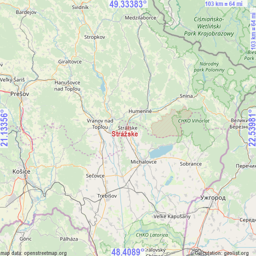
Strážske GPS coordinates[2]
48° 52' 24.6" North, 21° 50' 12.048" East
| Map corner | latitude | longitude |
|---|---|---|
| Upper-left | 49.33383°, | 21.13356° |
| Center: | 48.8735°, | 21.83668° |
| Lower-right: | 48.4089°, | 22.53981° |
| Map W x H: | 102.8×102.8 km | = 63.9×63.9mi |
| max Lat: | 49.43503° ⇑41.8% North |
| Strážske: | 48.8735° |
| min Lat: | ⇓58.2% South 47.76356° |
| min Long | Strážske | max Long |
| 16.9786° | 21.83668° | 22.18136° |
| W 95.3%⇐ | ⇒4.7% E |
Elevation
Elevation of Strážske is 134 m = 440 ft, and this is 202.1 m = 663 ft below average elevation for this country.
| Max E: |
1006 m = 3301 ft | 85.9% |
| Avg. | 336.1 m = 1103 ft | |
| Strážske | 134 m = 440 ft | |
Min E: |
102 m = 335 ft | 14.1% |
See also: Slovakia elevation on elevation.city.
Geographical zone
Strážske is located in North temperate zone (between Tropic of Cancer and the Arctic Circle). Distance of this North polar circle is 1967 km =1222.2 mi to North.| Distance of | km | miles | from Strážske |
|---|---|---|---|
| North Pole | 4572.8 | 2841.4 | to North |
| Arctic Circle | 1967 | 1222.2 | to North |
| Tropic Cancer | 2828.3 | 1757.4 | to South |
| Equator | 5434.2 | 3376.7 | to South |


Nearby cities:
15 places around Strážske: (largest is in red/bold)
• Chlmec
7.6 km =4.7 mi,  79°
79°
• Giraltovce
35.5 km =22.1 mi,  318°
318°
• Humenné
9.2 km =5.7 mi,  39°
39°
• Kavečany
47.4 km =29.5 mi,  256°
256°
• Košice
45.9 km =28.5 mi,  247°
247°
• Medzilaborce
44.5 km =27.7 mi,  6°
6°
• Michalovce
14.6 km =9.1 mi,  155°
155°
• Prešov
46.2 km =28.7 mi,  287°
287°
• Sečovce
23.1 km =14.4 mi,  213°
213°
• Snina
26.3 km =16.3 mi,  60°
60°
• Sobrance
29 km =18 mi,  119°
119°
• Stropkov
38.9 km =24.2 mi,  339°
339°
• Trebišov
28.6 km =17.8 mi,  197°
197°
• Vinné
11.9 km =7.4 mi,  126°
126°
• Vranov nad Topľou
11.2 km =7 mi,  278°
278°
Sources, notices
• [Note1] Compared only with cities in Slovakia existing in our database
• [Src1] Map data: © OpenStreetMap contributors (CC-BY-SA)
• [Src2] Other city data from geonames.org with taken over terms of usage.
• [Src3] Geographical zone / Annual Mean Temperature by Robert A. Rohde @ Wikipedia
