Bardejov geodata
Bardejov (Prešovský kraj) is a seat of a second-order administrative division; located in Slovakia in Europe/Bratislava (GMT+2) time zone. With population of 33,060 people, there are 20 cities with bigger population in this country. Compared to other cities in Slovakia, 92.9% of cities are located further ↓South; 91.2% of cities are located further ←West and 52.4% of cities have lower elevation than Bardejov. Note1


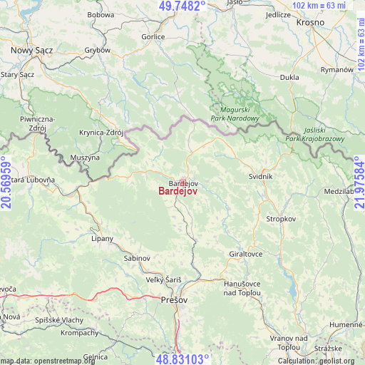
Bardejov GPS coordinates[2]
49° 17' 30.3" North, 21° 16' 21.756" East
| Map corner | latitude | longitude |
|---|---|---|
| Upper-left | 49.7482°, | 20.56959° |
| Center: | 49.29175°, | 21.27271° |
| Lower-right: | 48.83103°, | 21.97584° |
| Map W x H: | 102×102 km | = 63.4×63.4mi |
| max Lat: | 49.43503° ⇑7.1% North |
| Bardejov: | 49.29175° |
| min Lat: | ⇓92.9% South 47.76356° |
| min Long | Bardejov | max Long |
| 16.9786° | 21.27271° | 22.18136° |
| W 91.2%⇐ | ⇒8.8% E |
Elevation
Elevation of Bardejov is 283 m = 928 ft, and this is 53.1 m = 174 ft below average elevation for this country.
| Max E: |
1006 m = 3301 ft | 47.6% |
| Avg. | 336.1 m = 1103 ft | |
| Bardejov | 283 m = 928 ft | |
Min E: |
102 m = 335 ft | 52.4% |
See also: Slovakia elevation on elevation.city.
Geographical zone
Bardejov is located in North temperate zone (between Tropic of Cancer and the Arctic Circle). Distance of this North polar circle is 1920.4 km =1193.3 mi to North.| Distance of | km | miles | from Bardejov |
|---|---|---|---|
| North Pole | 4526.3 | 2812.5 | to North |
| Arctic Circle | 1920.4 | 1193.3 | to North |
| Tropic Cancer | 2874.8 | 1786.3 | to South |
| Equator | 5480.7 | 3405.5 | to South |


Nearby cities:
15 places around Bardejov: (largest is in red/bold)
• Bijacovce
45.5 km =28.3 mi,  229°
229°
• Giraltovce
26.6 km =16.5 mi,  138°
138°
• Krompachy
51 km =31.7 mi,  214°
214°
• Lipany
27.2 km =16.9 mi,  235°
235°
• Medzilaborce
45.6 km =28.3 mi,  92°
92°
• Podolínec
53.6 km =33.3 mi,  266°
266°
• Prešov
32.7 km =20.3 mi,  184°
184°
• Sabinov
24.5 km =15.2 mi, 211°
• Spišské Podhradie
49.7 km =30.9 mi, 229°
• Stará Ľubovňa
42.5 km =26.4 mi, 271°
• Stropkov
29.3 km =18.2 mi,  109°
109°
• Svidník
21.7 km =13.5 mi, 85°
• Vranov nad Topľou
54 km =33.6 mi,  146°
146°
• Vyšné Ružbachy
51.3 km =31.9 mi, 271°
• Žehra
49.3 km =30.6 mi, 225°
Sources, notices
• [Note1] Compared only with cities in Slovakia existing in our database
• [Src1] Map data: © OpenStreetMap contributors (CC-BY-SA)
• [Src2] Other city data from geonames.org with taken over terms of usage.
• [Src3] Geographical zone / Annual Mean Temperature by Robert A. Rohde @ Wikipedia
