Svidník geodata
Svidník (Prešovský kraj) is a seat of a second-order administrative division; located in Slovakia in Europe/Bratislava (GMT+2) time zone. With population of 12,428 people, there are 57 cities with bigger population in this country. Compared to other cities in Slovakia, 95.3% of cities are located further ↓South; 92.4% of cities are located further ←West and 57.6% of cities have higher elevation than Svidník. Note1


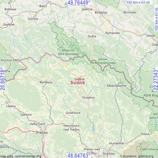
Svidník GPS coordinates[2]
49° 18' 29.484" North, 21° 34' 13.08" East
| Map corner | latitude | longitude |
|---|---|---|
| Upper-left | 49.76449°, | 20.86718° |
| Center: | 49.30819°, | 21.5703° |
| Lower-right: | 48.84763°, | 22.27343° |
| Map W x H: | 101.9×101.9 km | = 63.3×63.3mi |
| max Lat: | 49.43503° ⇑4.7% North |
| Svidník: | 49.30819° |
| min Lat: | ⇓95.3% South 47.76356° |
| min Long | Svidník | max Long |
| 16.9786° | 21.5703° | 22.18136° |
| W 92.4%⇐ | ⇒7.6% E |
Elevation
Elevation of Svidník is 229 m = 751 ft, and this is 107.1 m = 351 ft below average elevation for this country.
| Max E: |
1006 m = 3301 ft | 57.6% |
| Avg. | 336.1 m = 1103 ft | |
| Svidník | 229 m = 751 ft | |
Min E: |
102 m = 335 ft | 42.4% |
See also: Slovakia elevation on elevation.city.
Geographical zone
Svidník is located in North temperate zone (between Tropic of Cancer and the Arctic Circle). Distance of this North polar circle is 1918.6 km =1192.2 mi to North.| Distance of | km | miles | from Svidník |
|---|---|---|---|
| North Pole | 4524.5 | 2811.4 | to North |
| Arctic Circle | 1918.6 | 1192.2 | to North |
| Tropic Cancer | 2876.6 | 1787.4 | to South |
| Equator | 5482.6 | 3406.7 | to South |


Nearby cities:
15 places around Svidník: (largest is in red/bold)
• Bardejov
21.7 km =13.5 mi,  265°
265°
• Bijacovce
64.4 km =40 mi,  240°
240°
• Chlmec
54.1 km =33.6 mi,  150°
150°
• Giraltovce
21.9 km =13.6 mi,  190°
190°
• Humenné
48.3 km =30 mi, 148°
• Lipany
47.3 km =29.4 mi,  248°
248°
• Medzilaborce
24.3 km =15.1 mi,  99°
99°
• Prešov
42.2 km =26.2 mi,  215°
215°
• Sabinov
41.1 km =25.5 mi, 236°
• Snina
55.2 km =34.3 mi,  130°
130°
• Stará Ľubovňa
64.1 km =39.8 mi, 269°
• Stropkov
13.2 km =8.2 mi, 153°
• Strážske
52.1 km =32.4 mi,  158°
158°
• Vinné
62.5 km =38.8 mi, 152°
• Vranov nad Topľou
47.4 km =29.5 mi,  169°
169°
Sources, notices
• [Note1] Compared only with cities in Slovakia existing in our database
• [Src1] Map data: © OpenStreetMap contributors (CC-BY-SA)
• [Src2] Other city data from geonames.org with taken over terms of usage.
• [Src3] Geographical zone / Annual Mean Temperature by Robert A. Rohde @ Wikipedia
