Moyamba geodata
Moyamba (Southern Province) is a populated place; located in Sierra Leone in Africa/Freetown (GMT+0) time zone. With population of 6,700 people, there are 32 cities with bigger population in this country. Compared to other cities in Sierra Leone, 62.7% of cities are located further ↑North; 77.1% of cities are located further →East and 68.7% of cities have higher elevation than Moyamba. Note1


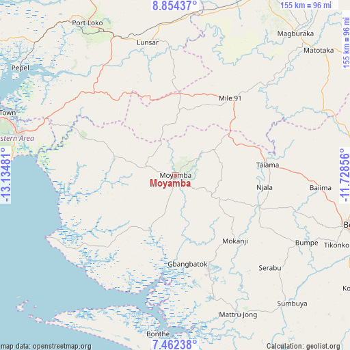
Moyamba GPS coordinates[2]
8° 9' 32.328" North, 12° 25' 54.048" West
| Map corner | latitude | longitude |
|---|---|---|
| Upper-left | 8.85437°, | -13.13481° |
| Center: | 8.15898°, | -12.43168° |
| Lower-right: | 7.46238°, | -11.72856° |
| Map W x H: | 154.8×154.8 km | = 96.2×96.2mi |
| max Lat: | 9.91376° ⇑62.7% North |
| Moyamba: | 8.15898° |
| min Lat: | ⇓37.3% South 7.24611° |
| min Long | Moyamba | max Long |
| -13.28972° | -12.43168° | -10.37135° |
| W 22.9%⇐ | ⇒77.1% E |
Elevation
Elevation of Moyamba is 58 m = 190 ft, and this is 99.2 m = 325 ft below average elevation for this country.
| Max E: |
564 m = 1850 ft | 68.7% |
| Avg. | 157.2 m = 516 ft | |
| Moyamba | 58 m = 190 ft | |
Min E: |
1 m = 3 ft | 31.3% |
See also: Sierra Leone elevation on elevation.city.
Geographical zone
Moyamba is located in North Torrid zone (between Equator and Tropic of Cancer). Distance of Equator is 907.2 km =563.7 mi to South.| Distance of | km | miles | from Moyamba |
|---|---|---|---|
| North Pole | 9099.9 | 5654.4 | to North |
| Arctic Circle | 6494 | 4035.2 | to North |
| Tropic Cancer | 1698.7 | 1055.5 | to North |
| Equator | 907.2 | 563.7 | to South |


Nearby cities:
15 places around Moyamba: (largest is in red/bold)
• Baiima
64.5 km =40.1 mi,  95°
95°
• Bo
79.3 km =49.3 mi,  105°
105°
• Bonthe
70.8 km =44 mi,  186°
186°
• Bumpe
65.1 km =40.5 mi,  117°
117°
• Kent
72.5 km =45 mi,  285°
285°
• Largo
33 km =20.5 mi,  66°
66°
• Lunsar
59.5 km =37 mi,  348°
348°
• Mogbwemo
46.1 km =28.6 mi,  162°
162°
• Port Loko
78 km =48.5 mi,  329°
329°
• Rokupr
57.2 km =35.5 mi,  5°
5°
• Rotifunk
28.1 km =17.5 mi, 285°
• Serabu
58.3 km =36.2 mi,  134°
134°
• Sumbuya
76.9 km =47.8 mi,  137°
137°
• Waterloo
73.1 km =45.4 mi, 285°
• Yonibana
38.1 km =23.7 mi,  33°
33°
Sources, notices
• [Note1] Compared only with cities in Sierra Leone existing in our database
• [Src1] Map data: © OpenStreetMap contributors (CC-BY-SA)
• [Src2] Other city data from geonames.org with taken over terms of usage.
• [Src3] Geographical zone / Annual Mean Temperature by Robert A. Rohde @ Wikipedia
