Largo geodata
Largo (Southern Province) is a populated place; located in Sierra Leone in Africa/Freetown (GMT+0) time zone. With population of 3,441 people, there are 65 cities with bigger population in this country. Compared to other cities in Sierra Leone, 54.2% of cities are located further ↑North; 71.1% of cities are located further →East and 56.6% of cities have higher elevation than Largo. Note1


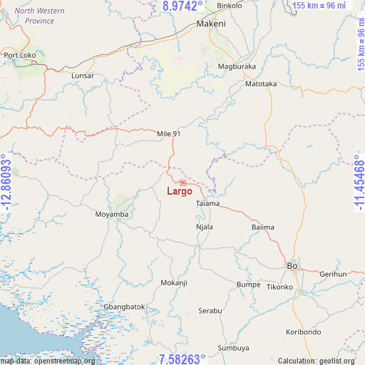
Largo GPS coordinates[2]
8° 16' 44.508" North, 12° 9' 28.08" West
| Map corner | latitude | longitude |
|---|---|---|
| Upper-left | 8.9742°, | -12.86093° |
| Center: | 8.27903°, | -12.1578° |
| Lower-right: | 7.58263°, | -11.45468° |
| Map W x H: | 154.7×154.7 km | = 96.1×96.1mi |
| max Lat: | 9.91376° ⇑54.2% North |
| Largo: | 8.27903° |
| min Lat: | ⇓45.8% South 7.24611° |
| min Long | Largo | max Long |
| -13.28972° | -12.1578° | -10.37135° |
| W 28.9%⇐ | ⇒71.1% E |
Elevation
Elevation of Largo is 86 m = 282 ft, and this is 71.2 m = 234 ft below average elevation for this country.
| Max E: |
564 m = 1850 ft | 56.6% |
| Avg. | 157.2 m = 516 ft | |
| Largo | 86 m = 282 ft | |
Min E: |
1 m = 3 ft | 43.4% |
See also: Sierra Leone elevation on elevation.city.
Geographical zone
Largo is located in North Torrid zone (between Equator and Tropic of Cancer). Distance of Equator is 920.5 km =572 mi to South.| Distance of | km | miles | from Largo |
|---|---|---|---|
| North Pole | 9086.5 | 5646.1 | to North |
| Arctic Circle | 6480.6 | 4026.9 | to North |
| Tropic Cancer | 1685.4 | 1047.3 | to North |
| Equator | 920.5 | 572 | to South |


Nearby cities:
15 places around Largo: (largest is in red/bold)
• Baiima
39.1 km =24.3 mi,  119°
119°
• Baoma
58.2 km =36.2 mi, 123°
• Bo
57.9 km =36 mi,  127°
127°
• Bumpe
51.2 km =31.8 mi,  147°
147°
• Lunsar
61.3 km =38.1 mi,  317°
317°
• Magburaka
54.5 km =33.9 mi,  24°
24°
• Mamboma
55.9 km =34.7 mi,  112°
112°
• Masaka
58 km =36 mi,  42°
42°
• Masingbi
60.3 km =37.5 mi, 22°
• Mogbwemo
59.8 km =37.2 mi,  196°
196°
• Moyamba
33 km =20.5 mi,  246°
246°
• Rokupr
50.3 km =31.3 mi,  330°
330°
• Rotifunk
57.5 km =35.7 mi,  264°
264°
• Serabu
55.2 km =34.3 mi,  167°
167°
• Yonibana
20.4 km =12.7 mi, 333°
Sources, notices
• [Note1] Compared only with cities in Sierra Leone existing in our database
• [Src1] Map data: © OpenStreetMap contributors (CC-BY-SA)
• [Src2] Other city data from geonames.org with taken over terms of usage.
• [Src3] Geographical zone / Annual Mean Temperature by Robert A. Rohde @ Wikipedia
