Baiima geodata
Baiima (Southern Province) is a populated place; located in Sierra Leone in Africa/Freetown (GMT+0) time zone. With population of 3,771 people, there are 57 cities with bigger population in this country. Compared to other cities in Sierra Leone, 66.3% of cities are located further ↑North; 59% of cities are located further →East and 63.9% of cities have higher elevation than Baiima. Note1


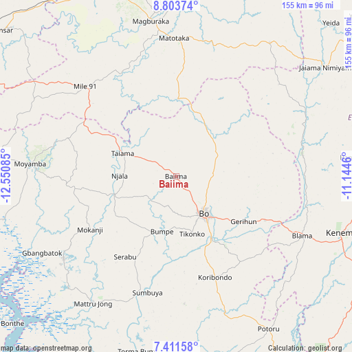
Baiima GPS coordinates[2]
8° 6' 29.736" North, 11° 50' 51.792" West
| Map corner | latitude | longitude |
|---|---|---|
| Upper-left | 8.80374°, | -12.55085° |
| Center: | 8.10826°, | -11.84772° |
| Lower-right: | 7.41158°, | -11.1446° |
| Map W x H: | 154.8×154.8 km | = 96.2×96.2mi |
| max Lat: | 9.91376° ⇑66.3% North |
| Baiima: | 8.10826° |
| min Lat: | ⇓33.7% South 7.24611° |
| min Long | Baiima | max Long |
| -13.28972° | -11.84772° | -10.37135° |
| W 41%⇐ | ⇒59% E |
Elevation
Elevation of Baiima is 69 m = 226 ft, and this is 88.2 m = 289 ft below average elevation for this country.
| Max E: |
564 m = 1850 ft | 63.9% |
| Avg. | 157.2 m = 516 ft | |
| Baiima | 69 m = 226 ft | |
Min E: |
1 m = 3 ft | 36.1% |
See also: Sierra Leone elevation on elevation.city.
Geographical zone
Baiima is located in North Torrid zone (between Equator and Tropic of Cancer). Distance of Equator is 901.6 km =560.2 mi to South.| Distance of | km | miles | from Baiima |
|---|---|---|---|
| North Pole | 9105.5 | 5657.9 | to North |
| Arctic Circle | 6499.6 | 4038.7 | to North |
| Tropic Cancer | 1704.4 | 1059.1 | to North |
| Equator | 901.6 | 560.2 | to South |


Nearby cities:
15 places around Baiima: (largest is in red/bold)
• Baoma
19.4 km =12.1 mi,  131°
131°
• Barma
62.9 km =39.1 mi,  64°
64°
• Blama
61.1 km =38 mi,  115°
115°
• Bo
20 km =12.4 mi,  142°
142°
• Boajibu
56.5 km =35.1 mi,  81°
81°
• Bumpe
24.9 km =15.5 mi,  194°
194°
• Koribundu
47.5 km =29.5 mi,  159°
159°
• Largo
39.1 km =24.3 mi,  299°
299°
• Makali
61.5 km =38.2 mi,  19°
19°
• Mamboma
17.7 km =11 mi,  97°
97°
• Masaka
62.1 km =38.6 mi,  4°
4°
• Palima
37.5 km =23.3 mi,  88°
88°
• Serabu
41.7 km =25.9 mi,  212°
212°
• Sumbuya
52.7 km =32.7 mi, 193°
• Yonibana
57 km =35.4 mi,  310°
310°
Sources, notices
• [Note1] Compared only with cities in Sierra Leone existing in our database
• [Src1] Map data: © OpenStreetMap contributors (CC-BY-SA)
• [Src2] Other city data from geonames.org with taken over terms of usage.
• [Src3] Geographical zone / Annual Mean Temperature by Robert A. Rohde @ Wikipedia
