Bo geodata
Bo (Southern Province) is a seat of a first-order administrative division; located in Sierra Leone in Africa/Freetown (GMT+0) time zone. With population of 174,354 people, there is 1 city with bigger population in this country. Compared to other cities in Sierra Leone, 74.7% of cities are located further ↑North; 54.2% of cities are located further →East and 50.6% of cities have higher elevation than Bo. Note1


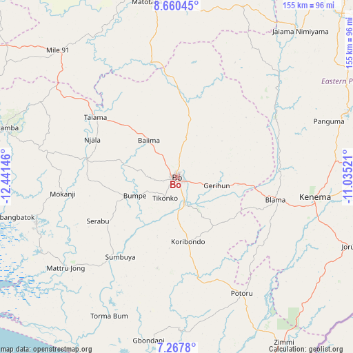
Bo GPS coordinates[2]
7° 57' 52.992" North, 11° 44' 17.988" West
| Map corner | latitude | longitude |
|---|---|---|
| Upper-left | 8.66045°, | -12.44146° |
| Center: | 7.96472°, | -11.73833° |
| Lower-right: | 7.2678°, | -11.03521° |
| Map W x H: | 154.8×154.9 km | = 96.2×96.3mi |
| max Lat: | 9.91376° ⇑74.7% North |
| Bo: | 7.96472° |
| min Lat: | ⇓25.3% South 7.24611° |
| min Long | Bo | max Long |
| -13.28972° | -11.73833° | -10.37135° |
| W 45.8%⇐ | ⇒54.2% E |
Elevation
Elevation of Bo is 104 m = 341 ft, and this is 53.2 m = 175 ft below average elevation for this country.
| Max E: |
564 m = 1850 ft | 50.6% |
| Avg. | 157.2 m = 516 ft | |
| Bo | 104 m = 341 ft | |
Min E: |
1 m = 3 ft | 49.4% |
See also: Bo elevation on elevation.city.
Geographical zone
Bo is located in North Torrid zone (between Equator and Tropic of Cancer). Distance of Equator is 885.6 km =550.3 mi to South.| Distance of | km | miles | from Bo |
|---|---|---|---|
| North Pole | 9121.5 | 5667.8 | to North |
| Arctic Circle | 6515.6 | 4048.6 | to North |
| Tropic Cancer | 1720.3 | 1068.9 | to North |
| Equator | 885.6 | 550.3 | to South |


Nearby cities:
15 places around Bo: (largest is in red/bold)
• Baiima
20 km =12.4 mi,  322°
322°
• Baoma
4.1 km =2.5 mi,  39°
39°
• Blama
44.4 km =27.6 mi,  103°
103°
• Boajibu
50.3 km =31.3 mi,  60°
60°
• Bumpe
20.1 km =12.5 mi,  246°
246°
• Gandorhun
45.8 km =28.5 mi,  173°
173°
• Gandorhun
53.3 km =33.1 mi,  191°
191°
• Gbewebu
48.2 km =30 mi,  162°
162°
• Koribundu
28.8 km =17.9 mi, 170°
• Largo
57.9 km =36 mi,  307°
307°
• Mamboma
14.7 km =9.1 mi,  21°
21°
• Palima
30.8 km =19.1 mi, 55°
• Potoru
58.5 km =36.4 mi,  150°
150°
• Serabu
39.6 km =24.6 mi,  241°
241°
• Sumbuya
42.9 km =26.7 mi,  214°
214°
Sources, notices
• [Note1] Compared only with cities in Sierra Leone existing in our database
• [Src1] Map data: © OpenStreetMap contributors (CC-BY-SA)
• [Src2] Other city data from geonames.org with taken over terms of usage.
• [Src3] Geographical zone / Annual Mean Temperature by Robert A. Rohde @ Wikipedia
