Bonthe geodata
Bonthe (Southern Province) is a populated place; located in Sierra Leone in Africa/Freetown (GMT+0) time zone. With population of 9,647 people, there are 20 cities with bigger population in this country. Compared to other cities in Sierra Leone, 90.4% of cities are located further ↑North; 78.3% of cities are located further →East and 98.8% of cities have higher elevation than Bonthe. Note1


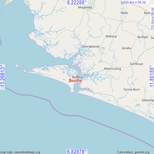
Bonthe GPS coordinates[2]
7° 31' 35.004" North, 12° 30' 18" West
| Map corner | latitude | longitude |
|---|---|---|
| Upper-left | 8.22288°, | -13.20813° |
| Center: | 7.52639°, | -12.505° |
| Lower-right: | 6.82878°, | -11.80188° |
| Map W x H: | 155×155 km | = 96.3×96.3mi |
| max Lat: | 9.91376° ⇑90.4% North |
| Bonthe: | 7.52639° |
| min Lat: | ⇓9.6% South 7.24611° |
| min Long | Bonthe | max Long |
| -13.28972° | -12.505° | -10.37135° |
| W 21.7%⇐ | ⇒78.3% E |
Elevation
Elevation of Bonthe is 5 m = 16 ft, and this is 152.2 m = 499 ft below average elevation for this country.
| Max E: |
564 m = 1850 ft | 98.8% |
| Avg. | 157.2 m = 516 ft | |
| Bonthe | 5 m = 16 ft | |
Min E: |
1 m = 3 ft | 1.2% |
See also: Sierra Leone elevation on elevation.city.
Geographical zone
Bonthe is located in North Torrid zone (between Equator and Tropic of Cancer). Distance of Equator is 836.9 km =520 mi to South.| Distance of | km | miles | from Bonthe |
|---|---|---|---|
| North Pole | 9170.2 | 5698.1 | to North |
| Arctic Circle | 6564.3 | 4078.9 | to North |
| Tropic Cancer | 1769.1 | 1099.3 | to North |
| Equator | 836.9 | 520 | to South |


Nearby cities:
15 places around Bonthe: (largest is in red/bold)
• Baiima
97.1 km =60.3 mi,  48°
48°
• Bo
97.5 km =60.6 mi,  60°
60°
• Bumpe
77.6 km =48.2 mi, 58°
• Gandorhun
74.4 km =46.2 mi,  92°
92°
• Gandorhun
89.6 km =55.7 mi, 87°
• Gbewebu
99 km =61.5 mi, 88°
• Koribundu
91.7 km =57 mi,  77°
77°
• Largo
92 km =57.2 mi,  24°
24°
• Mogbwemo
34 km =21.1 mi,  39°
39°
• Moyamba
70.8 km =44 mi,  6°
6°
• Pujehun
88.5 km =55 mi,  102°
102°
• Rotifunk
80.1 km =49.8 mi,  346°
346°
• Serabu
58 km =36 mi, 59°
• Sumbuya
61.5 km =38.2 mi, 77°
• Tongole
67.1 km =41.7 mi, 97°
Sources, notices
• [Note1] Compared only with cities in Sierra Leone existing in our database
• [Src1] Map data: © OpenStreetMap contributors (CC-BY-SA)
• [Src2] Other city data from geonames.org with taken over terms of usage.
• [Src3] Geographical zone / Annual Mean Temperature by Robert A. Rohde @ Wikipedia
