Ziguinchor geodata
Ziguinchor is a seat of a first-order administrative division; located in Senegal in Africa/Dakar (GMT+0) time zone. With population of 159,778 people, there are 7 cities with bigger population in this country. Compared to other cities in Senegal, 96.7% of cities are located further ↑North; 58.3% of cities are located further →East and 53.3% of cities have lower elevation than Ziguinchor. Note1


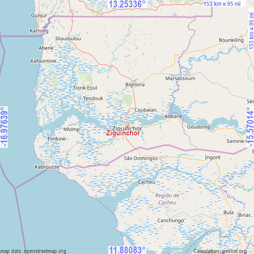
Ziguinchor GPS coordinates[2]
12° 34' 4.836" North, 16° 16' 23.736" West
| Map corner | latitude | longitude |
|---|---|---|
| Upper-left | 13.25336°, | -16.97639° |
| Center: | 12.56801°, | -16.27326° |
| Lower-right: | 11.88083°, | -15.57014° |
| Map W x H: | 152.6×152.6 km | = 94.8×94.8mi |
| max Lat: | 16.51293° ⇑96.7% North |
| Ziguinchor: | 12.56801° |
| min Lat: | ⇓3.3% South 12.485° |
| min Long | Ziguinchor | max Long |
| -17.47581° | -16.27326° | -12.18076° |
| W 41.7%⇐ | ⇒58.3% E |
Elevation
Elevation of Ziguinchor is 19 m = 62 ft, and this is 5.5 m = 18 ft below average elevation for this country.
| Max E: |
127 m = 417 ft | 46.7% |
| Avg. | 24.5 m = 80 ft | |
| Ziguinchor | 19 m = 62 ft | |
Min E: |
0 m = 0 ft | 53.3% |
See also: Ziguinchor elevation on elevation.city.
Geographical zone
Ziguinchor is located in North Torrid zone (between Equator and Tropic of Cancer). Distance of this Northern Tropic circle is 1208.5 km =750.9 mi to North.| Distance of | km | miles | from Ziguinchor |
|---|---|---|---|
| North Pole | 8609.6 | 5349.8 | to North |
| Arctic Circle | 6003.7 | 3730.5 | to North |
| Tropic Cancer | 1208.5 | 750.9 | to North |
| Equator | 1397.4 | 868.3 | to South |


Nearby cities:
15 places around Ziguinchor: (largest is in red/bold)
• Adéane
28.7 km =17.8 mi,  76°
76°
• Baboucar Toumbou
178 km =110.6 mi,  344°
344°
• Bignona
27.4 km =17 mi,  10°
10°
• Foundiougne
175.3 km =108.9 mi,  353°
353°
• Kaolack
177.5 km =110.3 mi, 7°
• Keur Babakar Toumbou
178 km =110.6 mi, 344°
• Kolda
148.9 km =92.5 mi, 75°
• Marsassoum
42.9 km =26.7 mi,  47°
47°
• Ndofane
154.4 km =95.9 mi, 13°
• Nioro du Rip
141.1 km =87.7 mi,  21°
21°
• Oussouye
31.1 km =19.3 mi,  252°
252°
• Passi
157.4 km =97.8 mi,  0°
0°
• Sokone
146.6 km =91.1 mi,  356°
356°
• Sédhiou
79.3 km =49.3 mi, 78°
• Tionk Essil
36.2 km =22.5 mi,  311°
311°
Sources, notices
• [Note1] Compared only with cities in Senegal existing in our database
• [Src1] Map data: © OpenStreetMap contributors (CC-BY-SA)
• [Src2] Other city data from geonames.org with taken over terms of usage.
• [Src3] Geographical zone / Annual Mean Temperature by Robert A. Rohde @ Wikipedia
