Bignona geodata
Bignona (Ziguinchor) is a populated place; located in Senegal in Africa/Dakar (GMT+0) time zone. With population of 26,237 people, there are 19 cities with bigger population in this country. Compared to other cities in Senegal, 90% of cities are located further ↑North; 50% of cities are located further ←West and 73.3% of cities have lower elevation than Bignona. Note1


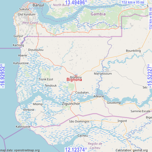
Bignona GPS coordinates[2]
12° 48' 37.008" North, 16° 13' 35.004" West
| Map corner | latitude | longitude |
|---|---|---|
| Upper-left | 13.49496°, | -16.92952° |
| Center: | 12.81028°, | -16.22639° |
| Lower-right: | 12.12374°, | -15.52327° |
| Map W x H: | 152.5×152.5 km | = 94.8×94.8mi |
| max Lat: | 16.51293° ⇑90% North |
| Bignona: | 12.81028° |
| min Lat: | ⇓10% South 12.485° |
| min Long | Bignona | max Long |
| -17.47581° | -16.22639° | -12.18076° |
| W 50%⇐ | ⇒50% E |
Elevation
Elevation of Bignona is 30 m = 98 ft, and this is 5.5 m = 18 ft above average elevation for this country.
| Max E: |
127 m = 417 ft | 26.7% |
| Bignona | 30 m 98 ft | |
| Avg. | 24.5 m = 80 ft | |
Min E: |
0 m = 0 ft | 73.3% |
See also: Senegal elevation on elevation.city.
Geographical zone
Bignona is located in North Torrid zone (between Equator and Tropic of Cancer). Distance of this Northern Tropic circle is 1181.5 km =734.1 mi to North.| Distance of | km | miles | from Bignona |
|---|---|---|---|
| North Pole | 8582.7 | 5333 | to North |
| Arctic Circle | 5976.8 | 3713.8 | to North |
| Tropic Cancer | 1181.5 | 734.1 | to North |
| Equator | 1424.4 | 885.1 | to South |


Nearby cities:
15 places around Bignona: (largest is in red/bold)
• Adéane
30.3 km =18.8 mi,  131°
131°
• Baboucar Toumbou
153.9 km =95.6 mi,  339°
339°
• Foundiougne
149.4 km =92.8 mi,  349°
349°
• Kaolack
150.1 km =93.3 mi,  6°
6°
• Keur Babakar Toumbou
153.9 km =95.6 mi, 339°
• Kolda
139.6 km =86.7 mi,  86°
86°
• Marsassoum
26.7 km =16.6 mi, 85°
• Ndofane
127 km =78.9 mi, 14°
• Nioro du Rip
114.2 km =71 mi,  23°
23°
• Oussouye
50.2 km =31.2 mi,  223°
223°
• Passi
130.5 km =81.1 mi,  358°
358°
• Sokone
120.3 km =74.8 mi, 352°
• Sédhiou
73.5 km =45.7 mi,  98°
98°
• Tionk Essil
32.1 km =19.9 mi,  265°
265°
• Ziguinchor
27.4 km =17 mi,  190°
190°
Sources, notices
• [Note1] Compared only with cities in Senegal existing in our database
• [Src1] Map data: © OpenStreetMap contributors (CC-BY-SA)
• [Src2] Other city data from geonames.org with taken over terms of usage.
• [Src3] Geographical zone / Annual Mean Temperature by Robert A. Rohde @ Wikipedia
