Adéane geodata
Adéane (Ziguinchor) is a populated place; located in Senegal in Africa/Dakar (GMT+0) time zone. With population of 2,115 people, there are 55 cities with bigger population in this country. Compared to other cities in Senegal, 95% of cities are located further ↑North; 55% of cities are located further ←West and 75% of cities have higher elevation than Adéane. Note1


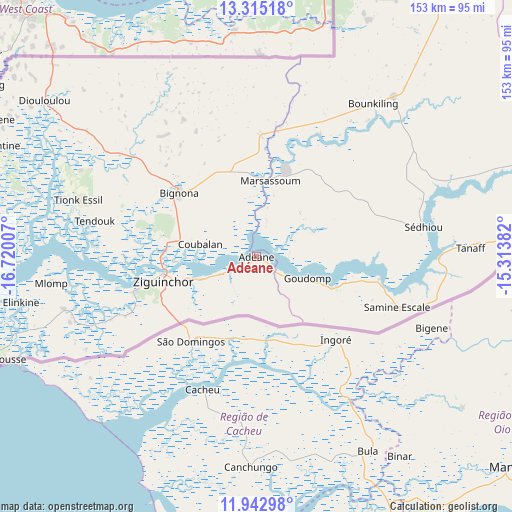
Adéane GPS coordinates[2]
12° 37' 48" North, 16° 1' 0.984" West
| Map corner | latitude | longitude |
|---|---|---|
| Upper-left | 13.31518°, | -16.72007° |
| Center: | 12.63°, | -16.01694° |
| Lower-right: | 11.94298°, | -15.31382° |
| Map W x H: | 152.6×152.6 km | = 94.8×94.8mi |
| max Lat: | 16.51293° ⇑95% North |
| Adéane: | 12.63° |
| min Lat: | ⇓5% South 12.485° |
| min Long | Adéane | max Long |
| -17.47581° | -16.01694° | -12.18076° |
| W 55%⇐ | ⇒45% E |
Elevation
Elevation of Adéane is 13 m = 43 ft, and this is 11.5 m = 38 ft below average elevation for this country.
| Max E: |
127 m = 417 ft | 75% |
| Avg. | 24.5 m = 80 ft | |
| Adéane | 13 m = 43 ft | |
Min E: |
0 m = 0 ft | 25% |
See also: Senegal elevation on elevation.city.
Geographical zone
Adéane is located in North Torrid zone (between Equator and Tropic of Cancer). Distance of this Northern Tropic circle is 1201.6 km =746.6 mi to North.| Distance of | km | miles | from Adéane |
|---|---|---|---|
| North Pole | 8602.7 | 5345.5 | to North |
| Arctic Circle | 5996.8 | 3726.2 | to North |
| Tropic Cancer | 1201.6 | 746.6 | to North |
| Equator | 1404.3 | 872.6 | to South |


Nearby cities:
15 places around Adéane: (largest is in red/bold)
• Bignona
30.3 km =18.8 mi,  311°
311°
• Foundiougne
174.1 km =108.2 mi,  343°
343°
• Gandiaye
180.3 km =112 mi,  351°
351°
• Kaffrine
171.7 km =106.7 mi,  17°
17°
• Kaolack
169.3 km =105.2 mi,  357°
357°
• Kolda
120.3 km =74.8 mi,  75°
75°
• Marsassoum
22.3 km =13.9 mi,  10°
10°
• Ndofane
143.4 km =89.1 mi,  3°
3°
• Nioro du Rip
126.7 km =78.7 mi, 10°
• Oussouye
59.7 km =37.1 mi,  254°
254°
• Passi
152.9 km =95 mi, 349°
• Sokone
144.4 km =89.7 mi, 344°
• Sédhiou
50.7 km =31.5 mi, 80°
• Tionk Essil
57.4 km =35.7 mi,  287°
287°
• Ziguinchor
28.7 km =17.8 mi,  256°
256°
Sources, notices
• [Note1] Compared only with cities in Senegal existing in our database
• [Src1] Map data: © OpenStreetMap contributors (CC-BY-SA)
• [Src2] Other city data from geonames.org with taken over terms of usage.
• [Src3] Geographical zone / Annual Mean Temperature by Robert A. Rohde @ Wikipedia
