Sédhiou geodata
Sédhiou is a seat of a first-order administrative division; located in Senegal in Africa/Dakar (GMT+0) time zone. With population of 19,702 people, there are 23 cities with bigger population in this country. Compared to other cities in Senegal, 93.3% of cities are located further ↑North; 70% of cities are located further ←West and 58.3% of cities have lower elevation than Sédhiou. Note1


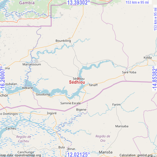
Sédhiou GPS coordinates[2]
12° 42' 29.016" North, 15° 33' 24.984" West
| Map corner | latitude | longitude |
|---|---|---|
| Upper-left | 13.39302°, | -16.26007° |
| Center: | 12.70806°, | -15.55694° |
| Lower-right: | 12.02125°, | -14.85382° |
| Map W x H: | 152.5×152.5 km | = 94.8×94.8mi |
| max Lat: | 16.51293° ⇑93.3% North |
| Sédhiou: | 12.70806° |
| min Lat: | ⇓6.7% South 12.485° |
| min Long | Sédhiou | max Long |
| -17.47581° | -15.55694° | -12.18076° |
| W 70%⇐ | ⇒30% E |
Elevation
Elevation of Sédhiou is 21 m = 69 ft, and this is 3.5 m = 11 ft below average elevation for this country.
| Max E: |
127 m = 417 ft | 41.7% |
| Avg. | 24.5 m = 80 ft | |
| Sédhiou | 21 m = 69 ft | |
Min E: |
0 m = 0 ft | 58.3% |
See also: Senegal elevation on elevation.city.
Geographical zone
Sédhiou is located in North Torrid zone (between Equator and Tropic of Cancer). Distance of this Northern Tropic circle is 1192.9 km =741.2 mi to North.| Distance of | km | miles | from Sédhiou |
|---|---|---|---|
| North Pole | 8594.1 | 5340.1 | to North |
| Arctic Circle | 5988.2 | 3720.9 | to North |
| Tropic Cancer | 1192.9 | 741.2 | to North |
| Equator | 1413 | 878 | to South |


Nearby cities:
15 places around Sédhiou: (largest is in red/bold)
• Adéane
50.7 km =31.5 mi,  260°
260°
• Bignona
73.5 km =45.7 mi,  278°
278°
• Kaffrine
155.4 km =96.6 mi,  0°
0°
• Kaolack
170 km =105.6 mi,  340°
340°
• Kolda
69.9 km =43.4 mi,  72°
72°
• Koungheul
163.7 km =101.7 mi,  30°
30°
• Marsassoum
47.8 km =29.7 mi,  286°
286°
• Ndofane
140.4 km =87.2 mi, 343°
• Nioro du Rip
118.8 km =73.8 mi,  347°
347°
• Oussouye
110.3 km =68.5 mi, 256°
• Passi
161.3 km =100.2 mi,  331°
331°
• Sokone
157.3 km =97.7 mi, 326°
• Tionk Essil
105 km =65.2 mi,  274°
274°
• Vélingara
163.6 km =101.7 mi, 72°
• Ziguinchor
79.3 km =49.3 mi, 258°
Sources, notices
• [Note1] Compared only with cities in Senegal existing in our database
• [Src1] Map data: © OpenStreetMap contributors (CC-BY-SA)
• [Src2] Other city data from geonames.org with taken over terms of usage.
• [Src3] Geographical zone / Annual Mean Temperature by Robert A. Rohde @ Wikipedia
