Kolda geodata
Kolda is a seat of a first-order administrative division; located in Senegal in Africa/Dakar (GMT+0) time zone. With population of 58,809 people, there are 12 cities with bigger population in this country. Compared to other cities in Senegal, 86.7% of cities are located further ↑North; 76.7% of cities are located further ←West and 63.3% of cities have higher elevation than Kolda. Note1


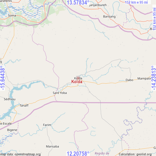
Kolda GPS coordinates[2]
12° 53' 38.04" North, 14° 56' 28.5" West
| Map corner | latitude | longitude |
|---|---|---|
| Upper-left | 13.57834°, | -15.64438° |
| Center: | 12.8939°, | -14.94125° |
| Lower-right: | 12.20758°, | -14.23813° |
| Map W x H: | 152.4×152.4 km | = 94.7×94.7mi |
| max Lat: | 16.51293° ⇑86.7% North |
| Kolda: | 12.8939° |
| min Lat: | ⇓13.3% South 12.485° |
| min Long | Kolda | max Long |
| -17.47581° | -14.94125° | -12.18076° |
| W 76.7%⇐ | ⇒23.3% E |
Elevation
Elevation of Kolda is 17 m = 56 ft, and this is 7.5 m = 25 ft below average elevation for this country.
| Max E: |
127 m = 417 ft | 63.3% |
| Avg. | 24.5 m = 80 ft | |
| Kolda | 17 m = 56 ft | |
Min E: |
0 m = 0 ft | 36.7% |
See also: Kolda elevation on elevation.city.
Geographical zone
Kolda is located in North Torrid zone (between Equator and Tropic of Cancer). Distance of this Northern Tropic circle is 1172.3 km =728.4 mi to North.| Distance of | km | miles | from Kolda |
|---|---|---|---|
| North Pole | 8573.4 | 5327.3 | to North |
| Arctic Circle | 5967.5 | 3708 | to North |
| Tropic Cancer | 1172.3 | 728.4 | to North |
| Equator | 1433.7 | 890.9 | to South |


Nearby cities:
15 places around Kolda: (largest is in red/bold)
• Adéane
120.3 km =74.8 mi,  255°
255°
• Bignona
139.6 km =86.7 mi,  266°
266°
• Guinguinéo
187.6 km =116.6 mi,  324°
324°
• Kaffrine
150 km =93.2 mi,  333°
333°
• Kaolack
185.8 km =115.5 mi, 318°
• Koungheul
122.1 km =75.9 mi,  7°
7°
• Marsassoum
112.9 km =70.2 mi, 266°
• Ndofane
156.4 km =97.2 mi, 316°
• Nioro du Rip
133 km =82.6 mi, 315°
• Oussouye
180 km =111.8 mi, 255°
• Sédhiou
69.9 km =43.4 mi,  252°
252°
• Tambacounda
168.8 km =104.9 mi,  54°
54°
• Tionk Essil
171.8 km =106.8 mi, 265°
• Vélingara
93.8 km =58.3 mi,  72°
72°
• Ziguinchor
148.9 km =92.5 mi, 255°
Sources, notices
• [Note1] Compared only with cities in Senegal existing in our database
• [Src1] Map data: © OpenStreetMap contributors (CC-BY-SA)
• [Src2] Other city data from geonames.org with taken over terms of usage.
• [Src3] Geographical zone / Annual Mean Temperature by Robert A. Rohde @ Wikipedia
