Buur Gaabo geodata
Buur Gaabo (Lower Juba) is a populated place; located in Somalia in Africa/Mogadishu (GMT+3) time zone. With population of 3,096 people, there are 46 cities with bigger population in this country. Compared to other cities in Somalia, 100% of cities are located further ↑North; 100% of cities are located further →East and 100% of cities have higher elevation than Buur Gaabo. Note1


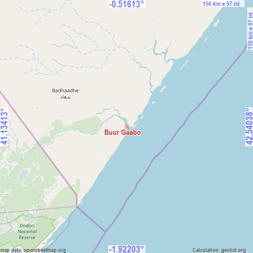
Buur Gaabo GPS coordinates[2]
1° 13' 9.012" South, 41° 50' 14.1" East
| Map corner | latitude | longitude |
|---|---|---|
| Upper-left | -0.51613°, | 41.13413° |
| Center: | -1.21917°, | 41.83725° |
| Lower-right: | -1.92203°, | 42.54038° |
| Map W x H: | 156.3×156.3 km | = 97.1×97.1mi |
| max Lat: | 11.96611° ⇑100% North |
| Buur Gaabo: | -1.21917° |
| min Lat: | ⇓0% South -1.21917° |
| min Long | Buur Gaabo | max Long |
| 41.83725° | 41.83725° | 51.0773° |
| W 0%⇐ | ⇒100% E |
Elevation
Elevation of Buur Gaabo is -2 m = -7 ft, and this is 291.9 m = 958 ft below average elevation for this country.
| Max E: |
1786 m = 5860 ft | 100% |
| Avg. | 289.9 m = 951 ft | |
| Buur Gaabo | -2 m = -7 ft | |
Min E: |
-2 m = -7 ft | 0% |
See also: Somalia elevation on elevation.city.
Geographical zone
Buur Gaabo is located in South Torrid zone (between Equator and Tropic of Capricorn). Distance of Equator is 135.6 km =84.3 mi to North.| Distance of | km | miles | from Buur Gaabo |
|---|---|---|---|
| Equator | 135.6 | 84.3 | to North |
| Tropic Capricorn | 2470.4 | 1535 | to South |
| Antarctic Circle | 7265.6 | 4514.6 | to South |
| South Pole | 9871.5 | 6133.9 | to South |


Nearby cities:
7 places around Buur Gaabo: (largest is in red/bold)
• Baardheere
399.3 km =248.1 mi,  7°
7°
• Bu’aale
269.1 km =167.2 mi,  17°
17°
• Dujuuma
286.8 km =178.2 mi, 16°
• Jamaame
175.3 km =108.9 mi,  35°
35°
• Jilib
217.2 km =135 mi,  29°
29°
• Kismayo
123.9 km =77 mi, 39°
• Saacow
323.6 km =201.1 mi, 11°
Sources, notices
• [Note1] Compared only with cities in Somalia existing in our database
• [Src1] Map data: © OpenStreetMap contributors (CC-BY-SA)
• [Src2] Other city data from geonames.org with taken over terms of usage.
• [Src3] Geographical zone / Annual Mean Temperature by Robert A. Rohde @ Wikipedia
