Jilib geodata
Jilib (Middle Juba) is a populated place; located in Somalia in Africa/Mogadishu (GMT+3) time zone. With population of 43,694 people, there are 16 cities with bigger population in this country. Compared to other cities in Somalia, 94.3% of cities are located further ↑North; 83% of cities are located further →East and 69.8% of cities have higher elevation than Jilib. Note1


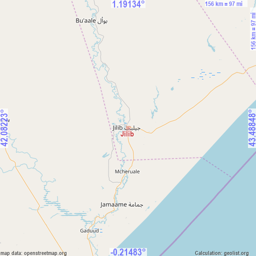
Jilib GPS coordinates[2]
0° 29' 17.844" North, 42° 47' 7.26" East
| Map corner | latitude | longitude |
|---|---|---|
| Upper-left | 1.19134°, | 42.08223° |
| Center: | 0.48829°, | 42.78535° |
| Lower-right: | -0.21483°, | 43.48848° |
| Map W x H: | 156.4×156.4 km | = 97.2×97.2mi |
| max Lat: | 11.96611° ⇑94.3% North |
| Jilib: | 0.48829° |
| min Lat: | ⇓5.7% South -1.21917° |
| min Long | Jilib | max Long |
| 41.83725° | 42.78535° | 51.0773° |
| W 17%⇐ | ⇒83% E |
Elevation
Elevation of Jilib is 25 m = 82 ft, and this is 264.9 m = 869 ft below average elevation for this country.
| Max E: |
1786 m = 5860 ft | 69.8% |
| Avg. | 289.9 m = 951 ft | |
| Jilib | 25 m = 82 ft | |
Min E: |
-2 m = -7 ft | 30.2% |
See also: Jilib elevation on elevation.city.
Geographical zone
Jilib is located in North Torrid zone (between Equator and Tropic of Cancer). Distance of Equator is 54.3 km =33.7 mi to South.| Distance of | km | miles | from Jilib |
|---|---|---|---|
| North Pole | 9952.8 | 6184.4 | to North |
| Arctic Circle | 7346.9 | 4565.2 | to North |
| Tropic Cancer | 2551.6 | 1585.5 | to North |
| Equator | 54.3 | 33.7 | to South |


Nearby cities:
15 places around Jilib: (largest is in red/bold)
• Afgooye
317.9 km =197.5 mi,  54°
54°
• Baardheere
214 km =133 mi,  344°
344°
• Baidoa
307.3 km =190.9 mi,  18°
18°
• Buur Gaabo
217.2 km =135 mi,  209°
209°
• Buurhakaba
294.7 km =183.1 mi,  29°
29°
• Bu’aale
69.9 km =43.4 mi, 341°
• Dujuuma
88.2 km =54.8 mi, 344°
• Garbahaarrey
322 km =200.1 mi,  348°
348°
• Jamaame
46.8 km =29.1 mi,  185°
185°
• Kismayo
97.8 km =60.8 mi,  195°
195°
• Marka
259.6 km =161.3 mi,  58°
58°
• Mogadishu
332.5 km =206.6 mi, 58°
• Qoryooley
241.9 km =150.3 mi, 53°
• Saacow
132.4 km =82.3 mi, 343°
• Wanlaweyn
333.2 km =207 mi,  44°
44°
Sources, notices
• [Note1] Compared only with cities in Somalia existing in our database
• [Src1] Map data: © OpenStreetMap contributors (CC-BY-SA)
• [Src2] Other city data from geonames.org with taken over terms of usage.
• [Src3] Geographical zone / Annual Mean Temperature by Robert A. Rohde @ Wikipedia
