Baardheere geodata
Baardheere (Gedo) is a populated locality; located in Somalia in Africa/Mogadishu (GMT+3) time zone. With population of 42,240 people, there are 17 cities with bigger population in this country. Compared to other cities in Somalia, 79.2% of cities are located further ↑North; 96.2% of cities are located further →East and 52.8% of cities have higher elevation than Baardheere. Note1


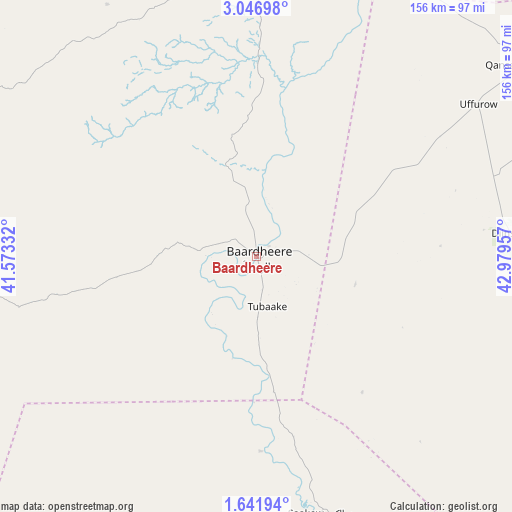
Baardheere GPS coordinates[2]
2° 20' 40.704" North, 42° 16' 35.184" East
| Map corner | latitude | longitude |
|---|---|---|
| Upper-left | 3.04698°, | 41.57332° |
| Center: | 2.34464°, | 42.27644° |
| Lower-right: | 1.64194°, | 42.97957° |
| Map W x H: | 156.2×156.2 km | = 97.1×97.1mi |
| max Lat: | 11.96611° ⇑79.2% North |
| Baardheere: | 2.34464° |
| min Lat: | ⇓20.8% South -1.21917° |
| min Long | Baardheere | max Long |
| 41.83725° | 42.27644° | 51.0773° |
| W 3.8%⇐ | ⇒96.2% E |
Elevation
Elevation of Baardheere is 97 m = 318 ft, and this is 192.9 m = 633 ft below average elevation for this country.
| Max E: |
1786 m = 5860 ft | 52.8% |
| Avg. | 289.9 m = 951 ft | |
| Baardheere | 97 m = 318 ft | |
Min E: |
-2 m = -7 ft | 47.2% |
See also: Baardheere elevation on elevation.city.
Geographical zone
Baardheere is located in North Torrid zone (between Equator and Tropic of Cancer). Distance of Equator is 260.7 km =162 mi to South.| Distance of | km | miles | from Baardheere |
|---|---|---|---|
| North Pole | 9746.4 | 6056.1 | to North |
| Arctic Circle | 7140.5 | 4436.9 | to North |
| Tropic Cancer | 2345.2 | 1457.2 | to North |
| Equator | 260.7 | 162 | to South |


Nearby cities:
15 places around Baardheere: (largest is in red/bold)
• Baidoa
174.9 km =108.7 mi,  60°
60°
• Buurhakaba
206.5 km =128.3 mi,  75°
75°
• Bu’aale
144.3 km =89.7 mi,  166°
166°
• Dujuuma
125.8 km =78.2 mi,  164°
164°
• Garbahaarrey
109.6 km =68.1 mi,  356°
356°
• Jamaame
258.3 km =160.5 mi, 168°
• Jilib
214 km =133 mi, 164°
• Luuq
164.9 km =102.5 mi,  10°
10°
• Marka
285.9 km =177.7 mi,  104°
104°
• Qoryooley
257.9 km =160.3 mi, 103°
• Saacow
81.8 km =50.8 mi, 167°
• Waajid
195.3 km =121.4 mi,  33°
33°
• Wanlaweyn
292.3 km =181.6 mi, 84°
• Xuddur
266.6 km =165.7 mi,  42°
42°
• Yeed
259.2 km =161.1 mi,  18°
18°
Sources, notices
• [Note1] Compared only with cities in Somalia existing in our database
• [Src1] Map data: © OpenStreetMap contributors (CC-BY-SA)
• [Src2] Other city data from geonames.org with taken over terms of usage.
• [Src3] Geographical zone / Annual Mean Temperature by Robert A. Rohde @ Wikipedia
