Kismayo geodata
Kismayo (Lower Juba) is a seat of a first-order administrative division; located in Somalia in Africa/Mogadishu (GMT+3) time zone. With population of 234,852 people, there are 3 cities with bigger population in this country. Compared to other cities in Somalia, 98.1% of cities are located further ↑North; 90.6% of cities are located further →East and 83% of cities have higher elevation than Kismayo. Note1


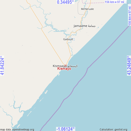
Kismayo GPS coordinates[2]
0° 21' 29.412" South, 42° 32' 43.296" East
| Map corner | latitude | longitude |
|---|---|---|
| Upper-left | 0.34495°, | 41.84224° |
| Center: | -0.35817°, | 42.54536° |
| Lower-right: | -1.06124°, | 43.24849° |
| Map W x H: | 156.4×156.4 km | = 97.2×97.2mi |
| max Lat: | 11.96611° ⇑98.1% North |
| Kismayo: | -0.35817° |
| min Lat: | ⇓1.9% South -1.21917° |
| min Long | Kismayo | max Long |
| 41.83725° | 42.54536° | 51.0773° |
| W 9.4%⇐ | ⇒90.6% E |
Elevation
Elevation of Kismayo is 11 m = 36 ft, and this is 278.9 m = 915 ft below average elevation for this country.
| Max E: |
1786 m = 5860 ft | 83% |
| Avg. | 289.9 m = 951 ft | |
| Kismayo | 11 m = 36 ft | |
Min E: |
-2 m = -7 ft | 17% |
See also: Kismayo elevation on elevation.city.
Geographical zone
Kismayo is located in South Torrid zone (between Equator and Tropic of Capricorn). Distance of Equator is 39.8 km =24.7 mi to North.| Distance of | km | miles | from Kismayo |
|---|---|---|---|
| Equator | 39.8 | 24.7 | to North |
| Tropic Capricorn | 2566.1 | 1594.5 | to South |
| Antarctic Circle | 7361.3 | 4574.1 | to South |
| South Pole | 9967.2 | 6193.3 | to South |


Nearby cities:
15 places around Kismayo: (largest is in red/bold)
• Afgooye
398.8 km =247.8 mi,  45°
45°
• Baardheere
302 km =187.7 mi,  354°
354°
• Baidoa
405.1 km =251.7 mi,  17°
17°
• Buur Gaabo
123.9 km =77 mi,  219°
219°
• Buurhakaba
390.6 km =242.7 mi,  25°
25°
• Bu’aale
160.3 km =99.6 mi,  1°
1°
• Dujuuma
179.2 km =111.3 mi, 1°
• Garbahaarrey
411.5 km =255.7 mi, 354°
• Jamaame
52.5 km =32.6 mi, 25°
• Jilib
97.8 km =60.8 mi, 15°
• Marka
338.3 km =210.2 mi, 47°
• Mogadishu
409.5 km =254.5 mi, 49°
• Qoryooley
325 km =201.9 mi,  42°
42°
• Saacow
221.1 km =137.4 mi,  356°
356°
• Wanlaweyn
421.5 km =261.9 mi, 38°
Sources, notices
• [Note1] Compared only with cities in Somalia existing in our database
• [Src1] Map data: © OpenStreetMap contributors (CC-BY-SA)
• [Src2] Other city data from geonames.org with taken over terms of usage.
• [Src3] Geographical zone / Annual Mean Temperature by Robert A. Rohde @ Wikipedia
