Saacow geodata
Saacow (Middle Juba) is a populated place; located in Somalia in Africa/Mogadishu (GMT+3) time zone. With population of 7,893 people, there are 37 cities with bigger population in this country. Compared to other cities in Somalia, 88.7% of cities are located further ↑North; 94.3% of cities are located further →East and 60.4% of cities have higher elevation than Saacow. Note1


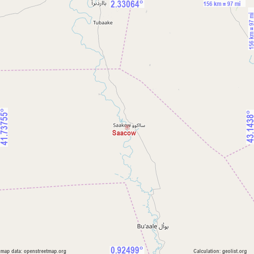
Saacow GPS coordinates[2]
1° 37' 40.584" North, 42° 26' 26.412" East
| Map corner | latitude | longitude |
|---|---|---|
| Upper-left | 2.33064°, | 41.73755° |
| Center: | 1.62794°, | 42.44067° |
| Lower-right: | 0.92499°, | 43.1438° |
| Map W x H: | 156.3×156.3 km | = 97.1×97.1mi |
| max Lat: | 11.96611° ⇑88.7% North |
| Saacow: | 1.62794° |
| min Lat: | ⇓11.3% South -1.21917° |
| min Long | Saacow | max Long |
| 41.83725° | 42.44067° | 51.0773° |
| W 5.7%⇐ | ⇒94.3% E |
Elevation
Elevation of Saacow is 63 m = 207 ft, and this is 226.9 m = 744 ft below average elevation for this country.
| Max E: |
1786 m = 5860 ft | 60.4% |
| Avg. | 289.9 m = 951 ft | |
| Saacow | 63 m = 207 ft | |
Min E: |
-2 m = -7 ft | 39.6% |
See also: Somalia elevation on elevation.city.
Geographical zone
Saacow is located in North Torrid zone (between Equator and Tropic of Cancer). Distance of Equator is 181 km =112.5 mi to South.| Distance of | km | miles | from Saacow |
|---|---|---|---|
| North Pole | 9826.1 | 6105.7 | to North |
| Arctic Circle | 7220.2 | 4486.4 | to North |
| Tropic Cancer | 2424.9 | 1506.8 | to North |
| Equator | 181 | 112.5 | to South |


Nearby cities:
15 places around Saacow: (largest is in red/bold)
• Afgooye
303.2 km =188.4 mi,  79°
79°
• Baardheere
81.8 km =50.8 mi,  347°
347°
• Baidoa
212.9 km =132.3 mi,  39°
39°
• Buurhakaba
223.9 km =139.1 mi,  54°
54°
• Bu’aale
62.6 km =38.9 mi,  165°
165°
• Dujuuma
44.2 km =27.5 mi,  160°
160°
• Garbahaarrey
190.7 km =118.5 mi, 352°
• Jamaame
176.5 km =109.7 mi, 168°
• Jilib
132.4 km =82.3 mi, 163°
• Kismayo
221.1 km =137.4 mi,  176°
176°
• Luuq
242.1 km =150.4 mi,  2°
2°
• Marka
259.3 km =161.1 mi,  87°
87°
• Qoryooley
232.9 km =144.7 mi, 85°
• Waajid
258.5 km =160.6 mi,  20°
20°
• Wanlaweyn
294 km =182.7 mi,  67°
67°
Sources, notices
• [Note1] Compared only with cities in Somalia existing in our database
• [Src1] Map data: © OpenStreetMap contributors (CC-BY-SA)
• [Src2] Other city data from geonames.org with taken over terms of usage.
• [Src3] Geographical zone / Annual Mean Temperature by Robert A. Rohde @ Wikipedia
