Jamaame geodata
Jamaame (Lower Juba) is a populated place; located in Somalia in Africa/Mogadishu (GMT+3) time zone. With population of 185,270 people, there are 5 cities with bigger population in this country. Compared to other cities in Somalia, 96.2% of cities are located further ↑North; 84.9% of cities are located further →East and 79.2% of cities have higher elevation than Jamaame. Note1


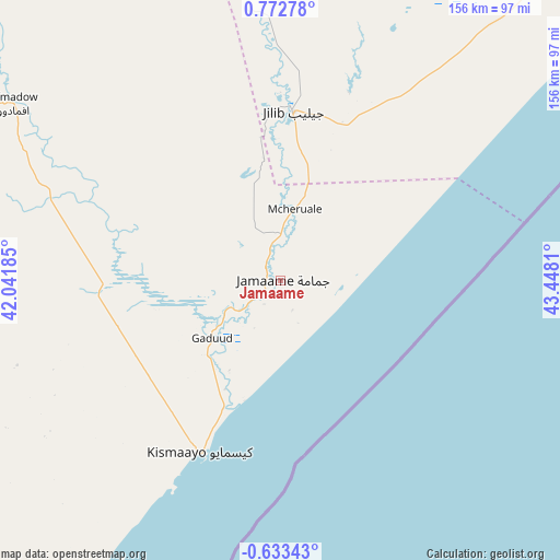
Jamaame GPS coordinates[2]
0° 4' 10.848" North, 42° 44' 41.892" East
| Map corner | latitude | longitude |
|---|---|---|
| Upper-left | 0.77278°, | 42.04185° |
| Center: | 0.06968°, | 42.74497° |
| Lower-right: | -0.63343°, | 43.4481° |
| Map W x H: | 156.4×156.4 km | = 97.2×97.2mi |
| max Lat: | 11.96611° ⇑96.2% North |
| Jamaame: | 0.06968° |
| min Lat: | ⇓3.8% South -1.21917° |
| min Long | Jamaame | max Long |
| 41.83725° | 42.74497° | 51.0773° |
| W 15.1%⇐ | ⇒84.9% E |
Elevation
Elevation of Jamaame is 12 m = 39 ft, and this is 277.9 m = 912 ft below average elevation for this country.
| Max E: |
1786 m = 5860 ft | 79.2% |
| Avg. | 289.9 m = 951 ft | |
| Jamaame | 12 m = 39 ft | |
Min E: |
-2 m = -7 ft | 20.8% |
See also: Jamaame elevation on elevation.city.
Geographical zone
Jamaame is located in North Torrid zone (between Equator and Tropic of Cancer). Distance of Equator is 7.7 km =4.8 mi to South.| Distance of | km | miles | from Jamaame |
|---|---|---|---|
| North Pole | 9999.3 | 6213.3 | to North |
| Arctic Circle | 7393.4 | 4594 | to North |
| Tropic Cancer | 2598.2 | 1614.4 | to North |
| Equator | 7.7 | 4.8 | to South |


Nearby cities:
15 places around Jamaame: (largest is in red/bold)
• Afgooye
350.2 km =217.6 mi,  48°
48°
• Baardheere
258.3 km =160.5 mi,  348°
348°
• Baidoa
353.1 km =219.4 mi,  16°
16°
• Buur Gaabo
175.3 km =108.9 mi,  215°
215°
• Buurhakaba
338.1 km =210.1 mi,  25°
25°
• Bu’aale
114.1 km =70.9 mi, 350°
• Dujuuma
133 km =82.6 mi, 351°
• Garbahaarrey
367 km =228 mi, 350°
• Jilib
46.8 km =29.1 mi,  5°
5°
• Kismayo
52.5 km =32.6 mi,  205°
205°
• Marka
290.3 km =180.4 mi, 50°
• Mogadishu
362.4 km =225.2 mi, 52°
• Qoryooley
275.5 km =171.2 mi, 46°
• Saacow
176.5 km =109.7 mi, 348°
• Wanlaweyn
370.6 km =230.3 mi,  40°
40°
Sources, notices
• [Note1] Compared only with cities in Somalia existing in our database
• [Src1] Map data: © OpenStreetMap contributors (CC-BY-SA)
• [Src2] Other city data from geonames.org with taken over terms of usage.
• [Src3] Geographical zone / Annual Mean Temperature by Robert A. Rohde @ Wikipedia
