Dujuuma geodata
Dujuuma (Middle Juba) is a populated place; located in Somalia in Africa/Mogadishu (GMT+3) time zone. With population of 2,432 people, there are 47 cities with bigger population in this country. Compared to other cities in Somalia, 90.6% of cities are located further ↑North; 88.7% of cities are located further →East and 62.3% of cities have higher elevation than Dujuuma. Note1


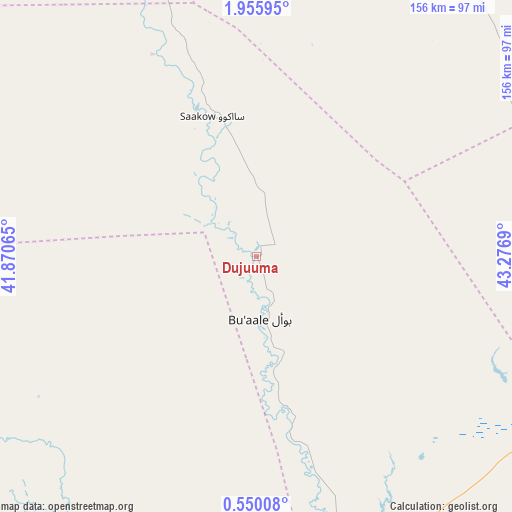
Dujuuma GPS coordinates[2]
1° 15' 11.196" North, 42° 34' 25.572" East
| Map corner | latitude | longitude |
|---|---|---|
| Upper-left | 1.95595°, | 41.87065° |
| Center: | 1.25311°, | 42.57377° |
| Lower-right: | 0.55008°, | 43.2769° |
| Map W x H: | 156.3×156.3 km | = 97.1×97.1mi |
| max Lat: | 11.96611° ⇑90.6% North |
| Dujuuma: | 1.25311° |
| min Lat: | ⇓9.4% South -1.21917° |
| min Long | Dujuuma | max Long |
| 41.83725° | 42.57377° | 51.0773° |
| W 11.3%⇐ | ⇒88.7% E |
Elevation
Elevation of Dujuuma is 57 m = 187 ft, and this is 232.9 m = 764 ft below average elevation for this country.
| Max E: |
1786 m = 5860 ft | 62.3% |
| Avg. | 289.9 m = 951 ft | |
| Dujuuma | 57 m = 187 ft | |
Min E: |
-2 m = -7 ft | 37.7% |
See also: Somalia elevation on elevation.city.
Geographical zone
Dujuuma is located in North Torrid zone (between Equator and Tropic of Cancer). Distance of Equator is 139.3 km =86.6 mi to South.| Distance of | km | miles | from Dujuuma |
|---|---|---|---|
| North Pole | 9867.7 | 6131.5 | to North |
| Arctic Circle | 7261.8 | 4512.3 | to North |
| Tropic Cancer | 2466.6 | 1532.7 | to North |
| Equator | 139.3 | 86.6 | to South |


Nearby cities:
15 places around Dujuuma: (largest is in red/bold)
• Baardheere
125.8 km =78.2 mi,  344°
344°
• Baidoa
238.9 km =148.4 mi,  30°
30°
• Buur Gaabo
286.8 km =178.2 mi,  196°
196°
• Buurhakaba
240 km =149.1 mi,  44°
44°
• Bu’aale
18.9 km =11.7 mi,  176°
176°
• Garbahaarrey
234.1 km =145.5 mi,  350°
350°
• Jamaame
133 km =82.6 mi,  171°
171°
• Jilib
88.2 km =54.8 mi,  164°
164°
• Kismayo
179.2 km =111.3 mi, 181°
• Luuq
283.6 km =176.2 mi,  359°
359°
• Marka
249.7 km =155.2 mi,  78°
78°
• Qoryooley
225.4 km =140.1 mi,  74°
74°
• Saacow
44.2 km =27.5 mi, 340°
• Waajid
293.9 km =182.6 mi,  14°
14°
• Wanlaweyn
299.2 km =185.9 mi,  59°
59°
Sources, notices
• [Note1] Compared only with cities in Somalia existing in our database
• [Src1] Map data: © OpenStreetMap contributors (CC-BY-SA)
• [Src2] Other city data from geonames.org with taken over terms of usage.
• [Src3] Geographical zone / Annual Mean Temperature by Robert A. Rohde @ Wikipedia
