Bu’aale geodata
Bu’aale (Middle Juba) is a seat of a first-order administrative division; located in Somalia in Africa/Mogadishu (GMT+3) time zone. In our database, there are 50 cities with bigger population. Compared to other cities in Somalia, 92.5% of cities are located further ↑North; 86.8% of cities are located further →East and 66% of cities have higher elevation than Bu’aale. Note1


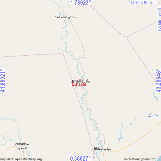
Bu’aale GPS coordinates[2]
1° 4' 59.988" North, 42° 34' 59.988" East
| Map corner | latitude | longitude |
|---|---|---|
| Upper-left | 1.78623°, | 41.88021° |
| Center: | 1.08333°, | 42.58333° |
| Lower-right: | 0.38027°, | 43.28646° |
| Map W x H: | 156.3×156.3 km | = 97.1×97.1mi |
| max Lat: | 11.96611° ⇑92.5% North |
| Bu’aale: | 1.08333° |
| min Lat: | ⇓7.5% South -1.21917° |
| min Long | Bu’aale | max Long |
| 41.83725° | 42.58333° | 51.0773° |
| W 13.2%⇐ | ⇒86.8% E |
Elevation
Elevation of Bu’aale is 44 m = 144 ft, and this is 245.9 m = 807 ft below average elevation for this country.
| Max E: |
1786 m = 5860 ft | 66% |
| Avg. | 289.9 m = 951 ft | |
| Bu’aale | 44 m = 144 ft | |
Min E: |
-2 m = -7 ft | 34% |
See also: Somalia elevation on elevation.city.
Geographical zone
Bu’aale is located in North Torrid zone (between Equator and Tropic of Cancer). Distance of Equator is 120.5 km =74.9 mi to South.| Distance of | km | miles | from Bu’aale |
|---|---|---|---|
| North Pole | 9886.6 | 6143.2 | to North |
| Arctic Circle | 7280.7 | 4524 | to North |
| Tropic Cancer | 2485.5 | 1544.4 | to North |
| Equator | 120.5 | 74.9 | to South |


Nearby cities:
15 places around Bu’aale: (largest is in red/bold)
• Afgooye
305.5 km =189.8 mi,  67°
67°
• Baardheere
144.3 km =89.7 mi,  346°
346°
• Baidoa
255 km =158.4 mi,  27°
27°
• Buur Gaabo
269.1 km =167.2 mi,  197°
197°
• Buurhakaba
253.2 km =157.3 mi,  40°
40°
• Dujuuma
18.9 km =11.7 mi,  356°
356°
• Garbahaarrey
252.9 km =157.1 mi, 350°
• Jamaame
114.1 km =70.9 mi,  170°
170°
• Jilib
69.9 km =43.4 mi,  161°
161°
• Kismayo
160.3 km =99.6 mi,  181°
181°
• Luuq
302.4 km =187.9 mi, 359°
• Marka
253.2 km =157.3 mi, 73°
• Qoryooley
230.1 km =143 mi, 70°
• Saacow
62.6 km =38.9 mi, 345°
• Wanlaweyn
308.3 km =191.6 mi,  56°
56°
Sources, notices
• [Note1] Compared only with cities in Somalia existing in our database
• [Src1] Map data: © OpenStreetMap contributors (CC-BY-SA)
• [Src2] Other city data from geonames.org with taken over terms of usage.
• [Src3] Geographical zone / Annual Mean Temperature by Robert A. Rohde @ Wikipedia
