Corinto geodata
Corinto (Morazán) is a populated place; located in El Salvador in America/El_Salvador (GMT-6) time zone. With population of 3,160 people, there are 77 cities with bigger population in this country. Compared to other cities in El Salvador, 73% of cities are located further ↓South; 93% of cities are located further ←West and 91% of cities have lower elevation than Corinto. Note1


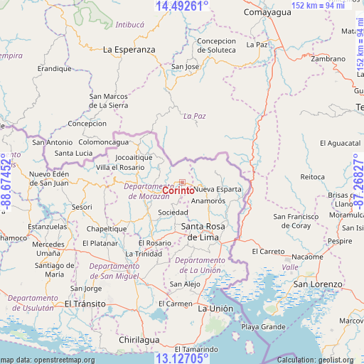
Corinto GPS coordinates[2]
13° 48' 38.988" North, 87° 58' 17.004" West
| Map corner | latitude | longitude |
|---|---|---|
| Upper-left | 14.49261°, | -88.67452° |
| Center: | 13.81083°, | -87.97139° |
| Lower-right: | 13.12705°, | -87.26827° |
| Map W x H: | 151.8×151.8 km | = 94.3×94.3mi |
| max Lat: | 14.33333° ⇑27% North |
| Corinto: | 13.81083° |
| min Lat: | ⇓73% South 13.19694° |
| min Long | Corinto | max Long |
| -90.01583° | -87.97139° | -87.83861° |
| W 93%⇐ | ⇒7% E |
Elevation
Elevation of Corinto is 848 m = 2782 ft, and this is 376.1 m = 1234 ft above average elevation for this country.
| Max E: |
1255 m = 4117 ft | 9% |
| Corinto | 848 m 2782 ft | |
| Avg. | 471.9 m = 1548 ft | |
Min E: |
13 m = 43 ft | 91% |
See also: El Salvador elevation on elevation.city.
Geographical zone
Corinto is located in North Torrid zone (between Equator and Tropic of Cancer). Distance of this Northern Tropic circle is 1070.3 km =665.1 mi to North.| Distance of | km | miles | from Corinto |
|---|---|---|---|
| North Pole | 8471.4 | 5263.9 | to North |
| Arctic Circle | 5865.6 | 3644.7 | to North |
| Tropic Cancer | 1070.3 | 665.1 | to North |
| Equator | 1535.6 | 954.2 | to South |


Nearby cities:
15 places around Corinto: (largest is in red/bold)
• Anamorós
13.1 km =8.1 mi,  126°
126°
• Cacaopera
13 km =8.1 mi,  247°
247°
• Chapeltique
37.5 km =23.3 mi,  238°
238°
• Ciudad Barrios
32.3 km =20.1 mi,  261°
261°
• Guatajiagua
29.4 km =18.3 mi, 237°
• Jocoro
22.1 km =13.7 mi,  192°
192°
• Moncagua
43.1 km =26.8 mi,  224°
224°
• Nueva Esparta
14.7 km =9.1 mi,  101°
101°
• Pasaquina
28.8 km =17.9 mi,  150°
150°
• San Alejo
42.2 km =26.2 mi,  178°
178°
• San Francisco
18.6 km =11.6 mi,  228°
228°
• San Miguel
43 km =26.7 mi,  212°
212°
• Santa Rosa de Lima
22.3 km =13.9 mi,  157°
157°
• Sesori
44 km =27.3 mi, 256°
• Sociedad
13.3 km =8.3 mi,  201°
201°
Sources, notices
• [Note1] Compared only with cities in El Salvador existing in our database
• [Src1] Map data: © OpenStreetMap contributors (CC-BY-SA)
• [Src2] Other city data from geonames.org with taken over terms of usage.
• [Src3] Geographical zone / Annual Mean Temperature by Robert A. Rohde @ Wikipedia
