Santa Rosa de Lima geodata
Santa Rosa de Lima (La Unión) is a populated place; located in El Salvador in America/El_Salvador (GMT-6) time zone. With population of 13,249 people, there are 37 cities with bigger population in this country. Compared to other cities in El Salvador, 65% of cities are located further ↑North; 95% of cities are located further ←West and 94% of cities have higher elevation than Santa Rosa de Lima. Note1


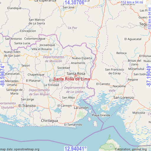
Santa Rosa de Lima GPS coordinates[2]
13° 37' 28.992" North, 87° 53' 36.996" West
| Map corner | latitude | longitude |
|---|---|---|
| Upper-left | 14.30706°, | -88.59674° |
| Center: | 13.62472°, | -87.89361° |
| Lower-right: | 12.94041°, | -87.19049° |
| Map W x H: | 152×152 km | = 94.4×94.4mi |
| max Lat: | 14.33333° ⇑65% North |
| Santa Rosa de Lima: | 13.62472° |
| min Lat: | ⇓35% South 13.19694° |
| min Long | Santa Rosa de L | max Long |
| -90.01583° | -87.89361° | -87.83861° |
| W 95%⇐ | ⇒5% E |
Elevation
Elevation of Santa Rosa de Lima is 96 m = 315 ft, and this is 375.9 m = 1233 ft below average elevation for this country.
| Max E: |
1255 m = 4117 ft | 94% |
| Avg. | 471.9 m = 1548 ft | |
| Santa Rosa de Lima | 96 m = 315 ft | |
Min E: |
13 m = 43 ft | 6% |
See also: El Salvador elevation on elevation.city.
Geographical zone
Santa Rosa de Lima is located in North Torrid zone (between Equator and Tropic of Cancer). Distance of this Northern Tropic circle is 1091 km =677.9 mi to North.| Distance of | km | miles | from Santa Rosa de Lima |
|---|---|---|---|
| North Pole | 8492.1 | 5276.7 | to North |
| Arctic Circle | 5886.2 | 3657.5 | to North |
| Tropic Cancer | 1091 | 677.9 | to North |
| Equator | 1514.9 | 941.3 | to South |


Nearby cities:
15 places around Santa Rosa de Lima: (largest is in red/bold)
• Anamorós
13.1 km =8.1 mi,  9°
9°
• Cacaopera
25.9 km =16.1 mi,  307°
307°
• Chapeltique
40.3 km =25 mi,  271°
271°
• Conchagua
35.4 km =22 mi,  174°
174°
• Corinto
22.3 km =13.9 mi,  337°
337°
• Guatajiagua
33.4 km =20.8 mi,  278°
278°
• Jocoro
13.3 km =8.3 mi, 266°
• La Unión
32.4 km =20.1 mi, 170°
• Moncagua
39.8 km =24.7 mi,  255°
255°
• Nueva Esparta
18.6 km =11.6 mi,  18°
18°
• Pasaquina
7.2 km =4.5 mi,  128°
128°
• San Alejo
22.8 km =14.2 mi,  199°
199°
• San Francisco
23.8 km =14.8 mi,  290°
290°
• San Miguel
35 km =21.7 mi,  243°
243°
• Sociedad
15.7 km =9.8 mi,  302°
302°
Sources, notices
• [Note1] Compared only with cities in El Salvador existing in our database
• [Src1] Map data: © OpenStreetMap contributors (CC-BY-SA)
• [Src2] Other city data from geonames.org with taken over terms of usage.
• [Src3] Geographical zone / Annual Mean Temperature by Robert A. Rohde @ Wikipedia
