Chalatenango geodata
Chalatenango is a seat of a first-order administrative division; located in El Salvador in America/El_Salvador (GMT-6) time zone. With population of 19,364 people, there are 26 cities with bigger population in this country. Compared to other cities in El Salvador, 95% of cities are located further ↓South; 56% of cities are located further ←West and 58% of cities have higher elevation than Chalatenango. Note1


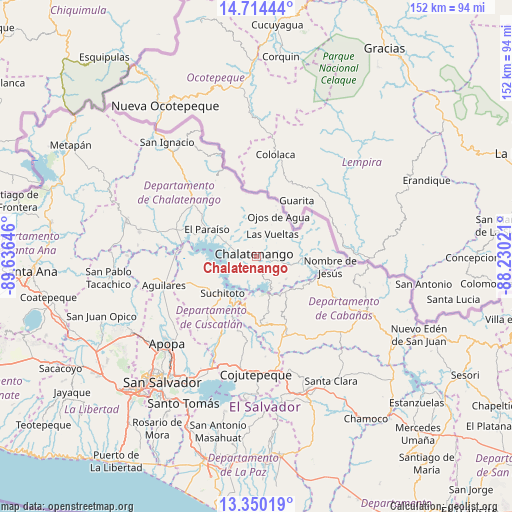
Chalatenango GPS coordinates[2]
14° 1' 59.988" North, 88° 55' 59.988" West
| Map corner | latitude | longitude |
|---|---|---|
| Upper-left | 14.71444°, | -89.63646° |
| Center: | 14.03333°, | -88.93333° |
| Lower-right: | 13.35019°, | -88.23021° |
| Map W x H: | 151.7×151.7 km | = 94.3×94.3mi |
| max Lat: | 14.33333° ⇑5% North |
| Chalatenango: | 14.03333° |
| min Lat: | ⇓95% South 13.19694° |
| min Long | Chalatenango | max Long |
| -90.01583° | -88.93333° | -87.83861° |
| W 56%⇐ | ⇒44% E |
Elevation
Elevation of Chalatenango is 406 m = 1332 ft, and this is 65.9 m = 216 ft below average elevation for this country.
| Max E: |
1255 m = 4117 ft | 58% |
| Avg. | 471.9 m = 1548 ft | |
| Chalatenango | 406 m = 1332 ft | |
Min E: |
13 m = 43 ft | 42% |
See also: El Salvador elevation on elevation.city.
Geographical zone
Chalatenango is located in North Torrid zone (between Equator and Tropic of Cancer). Distance of this Northern Tropic circle is 1045.6 km =649.7 mi to North.| Distance of | km | miles | from Chalatenango |
|---|---|---|---|
| North Pole | 8446.7 | 5248.5 | to North |
| Arctic Circle | 5840.8 | 3629.3 | to North |
| Tropic Cancer | 1045.6 | 649.7 | to North |
| Equator | 1560.4 | 969.6 | to South |


Nearby cities:
15 places around Chalatenango: (largest is in red/bold)
• Aguilares
28.9 km =18 mi,  252°
252°
• Apopa
36.6 km =22.7 mi,  226°
226°
• Cojutepeque
35.2 km =21.9 mi,  180°
180°
• El Paisnal
31.5 km =19.6 mi,  257°
257°
• Guazapa
31.2 km =19.4 mi,  236°
236°
• Nueva Concepción
41.1 km =25.5 mi,  285°
285°
• San Francisco Morazán
20.9 km =13 mi,  322°
322°
• San Martín
27.9 km =17.3 mi, 176°
• San Sebastián
35.1 km =21.8 mi,  162°
162°
• Sensuntepeque
37.3 km =23.2 mi,  119°
119°
• Suchitoto
14.7 km =9.1 mi,  223°
223°
• Tecoluca
28.2 km =17.5 mi,  195°
195°
• Tenancingo
22.9 km =14.2 mi,  193°
193°
• Tonacatepeque
34.4 km =21.4 mi, 215°
• Victoria
33.7 km =20.9 mi,  105°
105°
Sources, notices
• [Note1] Compared only with cities in El Salvador existing in our database
• [Src1] Map data: © OpenStreetMap contributors (CC-BY-SA)
• [Src2] Other city data from geonames.org with taken over terms of usage.
• [Src3] Geographical zone / Annual Mean Temperature by Robert A. Rohde @ Wikipedia
