Sarāqib geodata
Sarāqib (Idlib) is a seat of a third-order administrative division; located in Syria in Asia/Damascus (GMT+3) time zone. With population of 34,231 people, there are 40 cities with bigger population in this country. Compared to other cities in Syria, 73.9% of cities are located further ↓South; 65.4% of cities are located further ←West and 67.5% of cities have higher elevation than Sarāqib. Note1


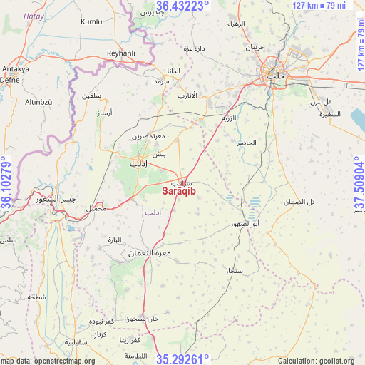
Sarāqib GPS coordinates[2]
35° 51' 52.092" North, 36° 48' 21.276" East
| Map corner | latitude | longitude |
|---|---|---|
| Upper-left | 36.43223°, | 36.10279° |
| Center: | 35.86447°, | 36.80591° |
| Lower-right: | 35.29261°, | 37.50904° |
| Map W x H: | 126.7×126.7 km | = 78.7×78.7mi |
| max Lat: | 37.17701° ⇑26.1% North |
| Sarāqib: | 35.86447° |
| min Lat: | ⇓73.9% South 32.39332° |
| min Long | Sarāqib | max Long |
| 35.75572° | 36.80591° | 42.14006° |
| W 65.4%⇐ | ⇒34.6% E |
Elevation
Elevation of Sarāqib is 366 m = 1201 ft, and this is 163.1 m = 535 ft below average elevation for this country.
| Max E: |
1640 m = 5381 ft | 67.5% |
| Avg. | 529.1 m = 1736 ft | |
| Sarāqib | 366 m = 1201 ft | |
Min E: |
4 m = 13 ft | 32.5% |
See also: Syria elevation on elevation.city.
Geographical zone
Sarāqib is located in North temperate zone (between Tropic of Cancer and the Arctic Circle). Distance of this Northern Tropic circle is 1381.8 km =858.6 mi to South.| Distance of | km | miles | from Sarāqib |
|---|---|---|---|
| North Pole | 6019.3 | 3740.2 | to North |
| Arctic Circle | 3413.4 | 2121 | to North |
| Tropic Cancer | 1381.8 | 858.6 | to South |
| Equator | 3987.8 | 2477.9 | to South |


Nearby cities:
15 places around Sarāqib: (largest is in red/bold)
• Abū az̧ Z̧uhūr
25.6 km =15.9 mi,  122°
122°
• Al Atārib
30.6 km =19 mi,  3°
3°
• Al Ḩāḑir
26.1 km =16.2 mi,  57°
57°
• Arīḩā
18.6 km =11.6 mi,  252°
252°
• Az Zarbah
27.5 km =17.1 mi,  34°
34°
• Binnish
13.2 km =8.2 mi,  321°
321°
• Idlib
17.1 km =10.6 mi,  295°
295°
• Iḩsim
27.6 km =17.1 mi,  234°
234°
• Ma‘arrat an Nu‘mān
26.7 km =16.6 mi,  205°
205°
• Ma‘arratmişrīn
20.3 km =12.6 mi, 323°
• Muḩambal
31.3 km =19.4 mi, 254°
• Qarqania
35.1 km =21.8 mi,  330°
330°
• Sarmīn
8.5 km =5.3 mi, 301°
• Sinjār
35.4 km =22 mi,  149°
149°
• Taftanāz
15 km =9.3 mi,  353°
353°
Sources, notices
• [Note1] Compared only with cities in Syria existing in our database
• [Src1] Map data: © OpenStreetMap contributors (CC-BY-SA)
• [Src2] Other city data from geonames.org with taken over terms of usage.
• [Src3] Geographical zone / Annual Mean Temperature by Robert A. Rohde @ Wikipedia
