‘Ayn al ‘Arab geodata
‘Ayn al ‘Arab (Aleppo) is a seat of a second-order administrative division; located in Syria in Asia/Damascus (GMT+3) time zone. With population of 50,000 people, there are 26 cities with bigger population in this country. Compared to other cities in Syria, 97.9% of cities are located further ↓South; 85.9% of cities are located further ←West and 57.6% of cities have lower elevation than ‘Ayn al ‘Arab. Note1


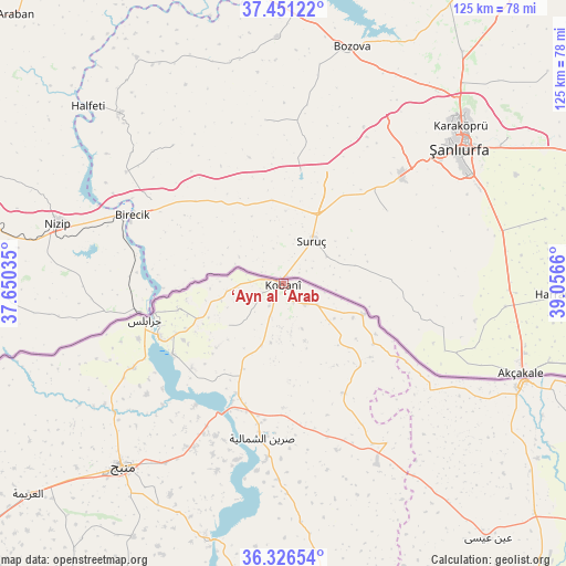
‘Ayn al ‘Arab GPS coordinates[2]
36° 53' 27.42" North, 38° 21' 12.492" East
| Map corner | latitude | longitude |
|---|---|---|
| Upper-left | 37.45122°, | 37.65035° |
| Center: | 36.89095°, | 38.35347° |
| Lower-right: | 36.32654°, | 39.0566° |
| Map W x H: | 125.1×125.1 km | = 77.7×77.7mi |
| max Lat: | 37.17701° ⇑2.1% North |
| ‘Ayn al ‘Arab: | 36.89095° |
| min Lat: | ⇓97.9% South 32.39332° |
| min Long | ‘Ayn al ‘Ar | max Long |
| 35.75572° | 38.35347° | 42.14006° |
| W 85.9%⇐ | ⇒14.1% E |
Elevation
Elevation of ‘Ayn al ‘Arab is 514 m = 1686 ft, and this is 15.1 m = 50 ft below average elevation for this country.
| Max E: |
1640 m = 5381 ft | 42.4% |
| Avg. | 529.1 m = 1736 ft | |
| ‘Ayn al ‘Arab | 514 m = 1686 ft | |
Min E: |
4 m = 13 ft | 57.6% |
See also: ‘Ayn al ‘Arab elevation on elevation.city.
Geographical zone
‘Ayn al ‘Arab is located in North temperate zone (between Tropic of Cancer and the Arctic Circle). Distance of this Northern Tropic circle is 1496 km =929.6 mi to South.| Distance of | km | miles | from ‘Ayn al ‘Arab |
|---|---|---|---|
| North Pole | 5905.2 | 3669.3 | to North |
| Arctic Circle | 3299.3 | 2050.1 | to North |
| Tropic Cancer | 1496 | 929.6 | to South |
| Equator | 4101.9 | 2548.8 | to South |


Nearby cities:
15 places around ‘Ayn al ‘Arab: (largest is in red/bold)
• Abū Qalqal
54.5 km =33.9 mi,  202°
202°
• Al Bāb
94.5 km =58.7 mi,  232°
232°
• Al Ghandūrah
60.5 km =37.6 mi,  245°
245°
• Al Jarnīyah
81.9 km =50.9 mi,  187°
187°
• Al Khafsah
79.1 km =49.2 mi, 201°
• Al ‘Arīmah
73.1 km =45.4 mi, 230°
• Jarābulus
31.5 km =19.6 mi, 254°
• Manbij
53.8 km =33.4 mi,  221°
221°
• Rasm al Ḩarmal
91.7 km =57 mi, 218°
• Shuyūkh Taḩtānī
29.2 km =18.1 mi,  237°
237°
• Sulūk
76.6 km =47.6 mi,  115°
115°
• Tall Abyaḑ
57.7 km =35.9 mi,  112°
112°
• Tchoban Bey
86.4 km =53.7 mi, 248°
• Şirrīn ash Shamālīyah
34 km =21.1 mi, 188°
• ‘Ayn ‘Īsá
72.2 km =44.9 mi,  141°
141°
Sources, notices
• [Note1] Compared only with cities in Syria existing in our database
• [Src1] Map data: © OpenStreetMap contributors (CC-BY-SA)
• [Src2] Other city data from geonames.org with taken over terms of usage.
• [Src3] Geographical zone / Annual Mean Temperature by Robert A. Rohde @ Wikipedia
