Nubl geodata
Nubl (Aleppo) is a seat of a third-order administrative division; located in Syria in Asia/Damascus (GMT+3) time zone. With population of 25,546 people, there are 60 cities with bigger population in this country. Compared to other cities in Syria, 86.6% of cities are located further ↓South; 69.3% of cities are located further ←West and 59.4% of cities have higher elevation than Nubl. Note1


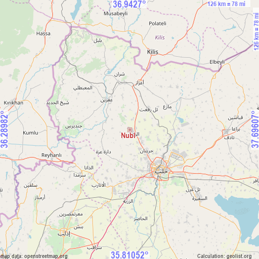
Nubl GPS coordinates[2]
36° 22' 43.212" North, 36° 59' 34.584" East
| Map corner | latitude | longitude |
|---|---|---|
| Upper-left | 36.9427°, | 36.28982° |
| Center: | 36.37867°, | 36.99294° |
| Lower-right: | 35.81052°, | 37.69607° |
| Map W x H: | 125.9×125.9 km | = 78.2×78.2mi |
| max Lat: | 37.17701° ⇑13.4% North |
| Nubl: | 36.37867° |
| min Lat: | ⇓86.6% South 32.39332° |
| min Long | Nubl | max Long |
| 35.75572° | 36.99294° | 42.14006° |
| W 69.3%⇐ | ⇒30.7% E |
Elevation
Elevation of Nubl is 413 m = 1355 ft, and this is 116.1 m = 381 ft below average elevation for this country.
| Max E: |
1640 m = 5381 ft | 59.4% |
| Avg. | 529.1 m = 1736 ft | |
| Nubl | 413 m = 1355 ft | |
Min E: |
4 m = 13 ft | 40.6% |
See also: Syria elevation on elevation.city.
Geographical zone
Nubl is located in North temperate zone (between Tropic of Cancer and the Arctic Circle). Distance of this Northern Tropic circle is 1439 km =894.2 mi to South.| Distance of | km | miles | from Nubl |
|---|---|---|---|
| North Pole | 5962.1 | 3704.7 | to North |
| Arctic Circle | 3356.2 | 2085.4 | to North |
| Tropic Cancer | 1439 | 894.2 | to South |
| Equator | 4044.9 | 2513.4 | to South |


Nearby cities:
15 places around Nubl: (largest is in red/bold)
• Ad Dānā
27.2 km =16.9 mi,  227°
227°
• Al Atārib
30.6 km =19 mi,  209°
209°
• Al Ma‘baţlī
30.3 km =18.8 mi,  312°
312°
• Aleppo
24.8 km =15.4 mi,  142°
142°
• Dārat ‘Izzah
16.5 km =10.3 mi, 229°
• I‘zāz
23.6 km =14.7 mi,  11°
11°
• Jindayris
27.3 km =17 mi,  273°
273°
• Kafr Şaghīr
25.4 km =15.8 mi,  112°
112°
• Māri‘
21.6 km =13.4 mi,  57°
57°
• Qenterê
31.3 km =19.4 mi, 310°
• Sharān
27.7 km =17.2 mi,  349°
349°
• Tall Rif‘at
13.8 km =8.6 mi,  41°
41°
• Şūrān
28.6 km =17.8 mi, 43°
• Ḩuraytān
13 km =8.1 mi, 140°
• ‘Afrīn
18.5 km =11.5 mi,  323°
323°
Sources, notices
• [Note1] Compared only with cities in Syria existing in our database
• [Src1] Map data: © OpenStreetMap contributors (CC-BY-SA)
• [Src2] Other city data from geonames.org with taken over terms of usage.
• [Src3] Geographical zone / Annual Mean Temperature by Robert A. Rohde @ Wikipedia
