Tall Rif‘at geodata
Tall Rif‘at (Aleppo) is a seat of a third-order administrative division; located in Syria in Asia/Damascus (GMT+3) time zone. With population of 25,658 people, there are 59 cities with bigger population in this country. Compared to other cities in Syria, 88.3% of cities are located further ↓South; 73.1% of cities are located further ←West and 52.7% of cities have lower elevation than Tall Rif‘at. Note1


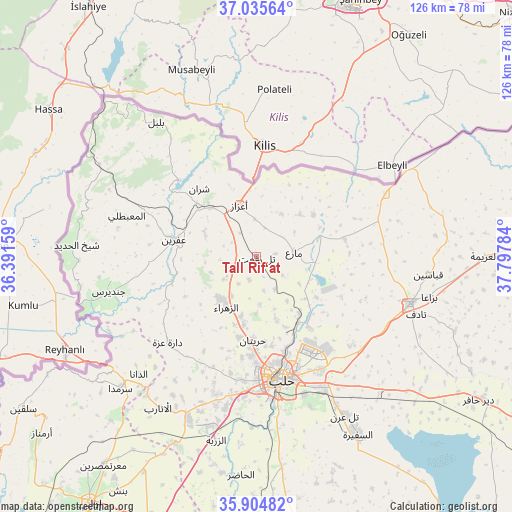
Tall Rif‘at GPS coordinates[2]
36° 28' 20.244" North, 37° 5' 40.956" East
| Map corner | latitude | longitude |
|---|---|---|
| Upper-left | 37.03564°, | 36.39159° |
| Center: | 36.47229°, | 37.09471° |
| Lower-right: | 35.90482°, | 37.79784° |
| Map W x H: | 125.7×125.7 km | = 78.1×78.1mi |
| max Lat: | 37.17701° ⇑11.7% North |
| Tall Rif‘at: | 36.47229° |
| min Lat: | ⇓88.3% South 32.39332° |
| min Long | Tall Rif‘at | max Long |
| 35.75572° | 37.09471° | 42.14006° |
| W 73.1%⇐ | ⇒26.9% E |
Elevation
Elevation of Tall Rif‘at is 486 m = 1594 ft, and this is 43.1 m = 141 ft below average elevation for this country.
| Max E: |
1640 m = 5381 ft | 47.3% |
| Avg. | 529.1 m = 1736 ft | |
| Tall Rif‘at | 486 m = 1594 ft | |
Min E: |
4 m = 13 ft | 52.7% |
See also: Syria elevation on elevation.city.
Geographical zone
Tall Rif‘at is located in North temperate zone (between Tropic of Cancer and the Arctic Circle). Distance of this Northern Tropic circle is 1449.4 km =900.6 mi to South.| Distance of | km | miles | from Tall Rif‘at |
|---|---|---|---|
| North Pole | 5951.7 | 3698.2 | to North |
| Arctic Circle | 3345.8 | 2079 | to North |
| Tropic Cancer | 1449.4 | 900.6 | to South |
| Equator | 4055.3 | 2519.8 | to South |


Nearby cities:
15 places around Tall Rif‘at: (largest is in red/bold)
• Akhtarīn
22 km =13.7 mi,  78°
78°
• Al Ma‘baţlī
33 km =20.5 mi,  287°
287°
• Aleppo
30.7 km =19.1 mi,  168°
168°
• Dārat ‘Izzah
30.3 km =18.8 mi,  225°
225°
• I‘zāz
13.4 km =8.3 mi,  341°
341°
• Jindayris
37.3 km =23.2 mi,  256°
256°
• Kafr Şaghīr
24.6 km =15.3 mi,  144°
144°
• Māri‘
9.2 km =5.7 mi, 82°
• Nubl
13.8 km =8.6 mi,  221°
221°
• Qenterê
34.3 km =21.3 mi, 287°
• Sharān
21.9 km =13.6 mi,  319°
319°
• Tchoban Bey
35.2 km =21.9 mi,  63°
63°
• Şūrān
14.8 km =9.2 mi,  45°
45°
• Ḩuraytān
20.4 km =12.7 mi,  182°
182°
• ‘Afrīn
20.6 km =12.8 mi,  282°
282°
Sources, notices
• [Note1] Compared only with cities in Syria existing in our database
• [Src1] Map data: © OpenStreetMap contributors (CC-BY-SA)
• [Src2] Other city data from geonames.org with taken over terms of usage.
• [Src3] Geographical zone / Annual Mean Temperature by Robert A. Rohde @ Wikipedia
