I‘zāz geodata
I‘zāz (Aleppo) is a seat of a second-order administrative division; located in Syria in Asia/Damascus (GMT+3) time zone. With population of 66,138 people, there are 17 cities with bigger population in this country. Compared to other cities in Syria, 92.2% of cities are located further ↓South; 70.3% of cities are located further ←West and 62.5% of cities have lower elevation than I‘zāz. Note1


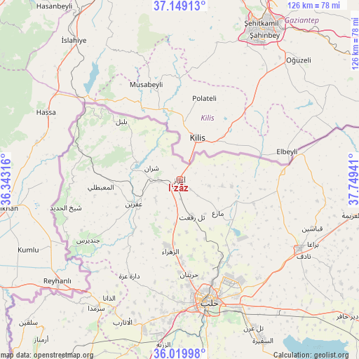
I‘zāz GPS coordinates[2]
36° 35' 11.832" North, 37° 2' 46.608" East
| Map corner | latitude | longitude |
|---|---|---|
| Upper-left | 37.14913°, | 36.34316° |
| Center: | 36.58662°, | 37.04628° |
| Lower-right: | 36.01998°, | 37.74941° |
| Map W x H: | 125.5×125.5 km | = 78×78mi |
| max Lat: | 37.17701° ⇑7.8% North |
| I‘zāz: | 36.58662° |
| min Lat: | ⇓92.2% South 32.39332° |
| min Long | I‘zāz | max Long |
| 35.75572° | 37.04628° | 42.14006° |
| W 70.3%⇐ | ⇒29.7% E |
Elevation
Elevation of I‘zāz is 559 m = 1834 ft, and this is 29.9 m = 98 ft above average elevation for this country.
| Max E: |
1640 m = 5381 ft | 37.5% |
| I‘zāz | 559 m 1834 ft | |
| Avg. | 529.1 m = 1736 ft | |
Min E: |
4 m = 13 ft | 62.5% |
See also: I‘zāz elevation on elevation.city.
Geographical zone
I‘zāz is located in North temperate zone (between Tropic of Cancer and the Arctic Circle). Distance of this Northern Tropic circle is 1462.1 km =908.5 mi to South.| Distance of | km | miles | from I‘zāz |
|---|---|---|---|
| North Pole | 5939 | 3690.3 | to North |
| Arctic Circle | 3333.1 | 2071.1 | to North |
| Tropic Cancer | 1462.1 | 908.5 | to South |
| Equator | 4068.1 | 2527.8 | to South |


Nearby cities:
15 places around I‘zāz: (largest is in red/bold)
• Akhtarīn
27.2 km =16.9 mi,  108°
108°
• Al Ma‘baţlī
27.2 km =16.9 mi,  264°
264°
• Bulbul
28.7 km =17.8 mi,  315°
315°
• Dārat ‘Izzah
38 km =23.6 mi,  207°
207°
• Kafr Şaghīr
37.7 km =23.4 mi,  150°
150°
• Māri‘
17.8 km =11.1 mi,  130°
130°
• Nubl
23.6 km =14.7 mi,  191°
191°
• Qenterê
28.5 km =17.7 mi, 264°
• Radjun
35.5 km =22.1 mi,  286°
286°
• Sharān
10.6 km =6.6 mi, 292°
• Tall Rif‘at
13.4 km =8.3 mi,  161°
161°
• Tchoban Bey
36 km =22.4 mi,  85°
85°
• Şūrān
15 km =9.3 mi,  98°
98°
• Ḩuraytān
33.3 km =20.7 mi,  173°
173°
• ‘Afrīn
17.8 km =11.1 mi,  242°
242°
Sources, notices
• [Note1] Compared only with cities in Syria existing in our database
• [Src1] Map data: © OpenStreetMap contributors (CC-BY-SA)
• [Src2] Other city data from geonames.org with taken over terms of usage.
• [Src3] Geographical zone / Annual Mean Temperature by Robert A. Rohde @ Wikipedia
