Aleppo geodata
Aleppo is a seat of a first-order administrative division; located in Syria in Asia/Damascus (GMT+3) time zone. With population of 1,602,264 people, there are 0 cities with bigger population in this country. Compared to other cities in Syria, 82.7% of cities are located further ↓South; 73.5% of cities are located further ←West and 60.4% of cities have higher elevation than Aleppo. Note1


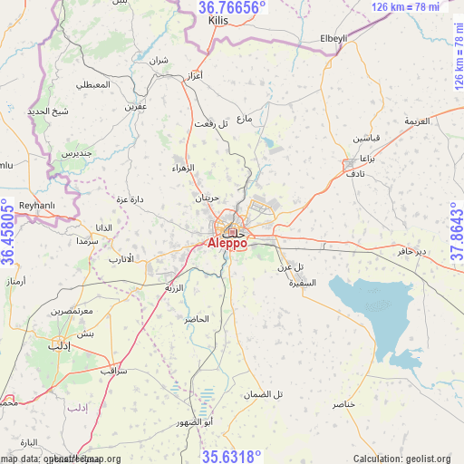
Aleppo GPS coordinates[2]
36° 12' 4.464" North, 37° 9' 40.212" East
| Map corner | latitude | longitude |
|---|---|---|
| Upper-left | 36.76656°, | 36.45805° |
| Center: | 36.20124°, | 37.16117° |
| Lower-right: | 35.6318°, | 37.8643° |
| Map W x H: | 126.2×126.2 km | = 78.4×78.4mi |
| max Lat: | 37.17701° ⇑17.3% North |
| Aleppo: | 36.20124° |
| min Lat: | ⇓82.7% South 32.39332° |
| min Long | Aleppo | max Long |
| 35.75572° | 37.16117° | 42.14006° |
| W 73.5%⇐ | ⇒26.5% E |
Elevation
Elevation of Aleppo is 401 m = 1316 ft, and this is 128.1 m = 420 ft below average elevation for this country.
| Max E: |
1640 m = 5381 ft | 60.4% |
| Avg. | 529.1 m = 1736 ft | |
| Aleppo | 401 m = 1316 ft | |
Min E: |
4 m = 13 ft | 39.6% |
See also: Aleppo elevation on elevation.city.
Geographical zone
Aleppo is located in North temperate zone (between Tropic of Cancer and the Arctic Circle). Distance of this Northern Tropic circle is 1419.3 km =881.9 mi to South.| Distance of | km | miles | from Aleppo |
|---|---|---|---|
| North Pole | 5981.9 | 3717 | to North |
| Arctic Circle | 3376 | 2097.7 | to North |
| Tropic Cancer | 1419.3 | 881.9 | to South |
| Equator | 4025.2 | 2501.1 | to South |


Nearby cities:
15 places around Aleppo: (largest is in red/bold)
• Ad Dānā
35.1 km =21.8 mi,  272°
272°
• Al Atārib
31 km =19.3 mi,  257°
257°
• Al Bāb
36.9 km =22.9 mi,  59°
59°
• Al Ḩāḑir
25.5 km =15.8 mi,  202°
202°
• As Safīrah
23.5 km =14.6 mi,  126°
126°
• Az Zarbah
22 km =13.7 mi,  227°
227°
• Banān
28.3 km =17.6 mi,  153°
153°
• Dārat ‘Izzah
29.1 km =18.1 mi,  288°
288°
• Kafr Şaghīr
13.2 km =8.2 mi,  39°
39°
• Kuwayris Sharqī
34 km =21.1 mi,  96°
96°
• Māri‘
31.4 km =19.5 mi,  5°
5°
• Nubl
24.8 km =15.4 mi,  322°
322°
• Tall Rif‘at
30.7 km =19.1 mi,  348°
348°
• Tādif
36.9 km =22.9 mi, 63°
• Ḩuraytān
11.9 km =7.4 mi, 324°
Sources, notices
• [Note1] Compared only with cities in Syria existing in our database
• [Src1] Map data: © OpenStreetMap contributors (CC-BY-SA)
• [Src2] Other city data from geonames.org with taken over terms of usage.
• [Src3] Geographical zone / Annual Mean Temperature by Robert A. Rohde @ Wikipedia
