Nawá geodata
Nawá (Daraa) is a seat of a third-order administrative division; located in Syria in Asia/Damascus (GMT+3) time zone. In our database, there are 87 cities with bigger population. Compared to other cities in Syria, 91.5% of cities are located further ↑North; 89.8% of cities are located further →East and 63.6% of cities have lower elevation than Nawá. Note1


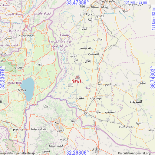
Nawá GPS coordinates[2]
32° 53' 25.584" North, 36° 2' 23.64" East
| Map corner | latitude | longitude |
|---|---|---|
| Upper-left | 33.47889°, | 35.33678° |
| Center: | 32.89044°, | 36.0399° |
| Lower-right: | 32.29806°, | 36.74303° |
| Map W x H: | 131.3×131.3 km | = 81.6×81.6mi |
| max Lat: | 37.17701° ⇑91.5% North |
| Nawá: | 32.89044° |
| min Lat: | ⇓8.5% South 32.39332° |
| min Long | Nawá | max Long |
| 35.75572° | 36.0399° | 42.14006° |
| W 10.2%⇐ | ⇒89.8% E |
Elevation
Elevation of Nawá is 571 m = 1873 ft, and this is 41.9 m = 137 ft above average elevation for this country.
| Max E: |
1640 m = 5381 ft | 36.4% |
| Nawá | 571 m 1873 ft | |
| Avg. | 529.1 m = 1736 ft | |
Min E: |
4 m = 13 ft | 63.6% |
See also: Syria elevation on elevation.city.
Geographical zone
Nawá is located in North temperate zone (between Tropic of Cancer and the Arctic Circle). Distance of this Northern Tropic circle is 1051.2 km =653.2 mi to South.| Distance of | km | miles | from Nawá |
|---|---|---|---|
| North Pole | 6350 | 3945.7 | to North |
| Arctic Circle | 3744.1 | 2326.5 | to North |
| Tropic Cancer | 1051.2 | 653.2 | to South |
| Equator | 3657.1 | 2272.4 | to South |


Nearby cities:
15 places around Nawá: (largest is in red/bold)
• Al Muzayrīb
20 km =12.4 mi,  183°
183°
• Al Qunayţirah
33 km =20.5 mi,  322°
322°
• Al Ḩarāk
29.7 km =18.5 mi,  121°
121°
• Ash Shajarah
19.6 km =12.2 mi,  228°
228°
• Ash Shaykh Miskīn
13.1 km =8.1 mi, 121°
• Aş Şanamayn
24.2 km =15 mi,  33°
33°
• Dar‘ā
30.7 km =19.1 mi,  169°
169°
• Dā‘il
17.3 km =10.7 mi,  150°
150°
• Inkhil
16.4 km =10.2 mi, 30°
• Izra‘
20.2 km =12.6 mi,  96°
96°
• Jāsim
11.5 km =7.1 mi,  9°
9°
• Khirbat Ghazālah
23.2 km =14.4 mi,  138°
138°
• Khān Arnabah
35.4 km =22 mi,  337°
337°
• Tasīl
9.1 km =5.7 mi, 226°
• Ţafas
17.2 km =10.7 mi, 171°
Sources, notices
• [Note1] Compared only with cities in Syria existing in our database
• [Src1] Map data: © OpenStreetMap contributors (CC-BY-SA)
• [Src2] Other city data from geonames.org with taken over terms of usage.
• [Src3] Geographical zone / Annual Mean Temperature by Robert A. Rohde @ Wikipedia
