Al Ḩarāk geodata
Al Ḩarāk (Daraa) is a seat of a third-order administrative division; located in Syria in Asia/Damascus (GMT+3) time zone. With population of 23,784 people, there are 63 cities with bigger population in this country. Compared to other cities in Syria, 95.1% of cities are located further ↑North; 69.3% of cities are located further →East and 70.7% of cities have lower elevation than Al Ḩarāk. Note1


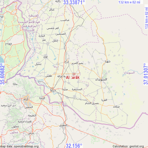
Al Ḩarāk GPS coordinates[2]
32° 44' 57.552" North, 36° 18' 35.784" East
| Map corner | latitude | longitude |
|---|---|---|
| Upper-left | 33.33871°, | 35.60682° |
| Center: | 32.74932°, | 36.30994° |
| Lower-right: | 32.156°, | 37.01307° |
| Map W x H: | 131.5×131.5 km | = 81.7×81.7mi |
| max Lat: | 37.17701° ⇑95.1% North |
| Al Ḩarāk: | 32.74932° |
| min Lat: | ⇓4.9% South 32.39332° |
| min Long | Al Ḩarāk | max Long |
| 35.75572° | 36.30994° | 42.14006° |
| W 30.7%⇐ | ⇒69.3% E |
Elevation
Elevation of Al Ḩarāk is 635 m = 2083 ft, and this is 105.9 m = 347 ft above average elevation for this country.
| Max E: |
1640 m = 5381 ft | 29.3% |
| Al Ḩarāk | 635 m 2083 ft | |
| Avg. | 529.1 m = 1736 ft | |
Min E: |
4 m = 13 ft | 70.7% |
See also: Syria elevation on elevation.city.
Geographical zone
Al Ḩarāk is located in North temperate zone (between Tropic of Cancer and the Arctic Circle). Distance of this Northern Tropic circle is 1035.5 km =643.4 mi to South.| Distance of | km | miles | from Al Ḩarāk |
|---|---|---|---|
| North Pole | 6365.7 | 3955.5 | to North |
| Arctic Circle | 3759.8 | 2336.2 | to North |
| Tropic Cancer | 1035.5 | 643.4 | to South |
| Equator | 3641.4 | 2262.7 | to South |


Nearby cities:
15 places around Al Ḩarāk: (largest is in red/bold)
• Al Jīzah
20 km =12.4 mi,  178°
178°
• Al Mazra‘ah
16.1 km =10 mi,  76°
76°
• Al Musayfirah
13.3 km =8.3 mi,  168°
168°
• Al Muzayrīb
26.8 km =16.7 mi,  260°
260°
• As-Suwayda
24.7 km =15.3 mi,  100°
100°
• Ash Shaykh Miskīn
16.7 km =10.4 mi,  302°
302°
• Buşrá ash Shām
30.2 km =18.8 mi,  147°
147°
• Dar‘ā
24.3 km =15.1 mi,  233°
233°
• Dā‘il
16.9 km =10.5 mi,  272°
272°
• Izra‘
14.4 km =8.9 mi,  338°
338°
• Khirbat Ghazālah
10 km =6.2 mi, 260°
• Nawá
29.7 km =18.5 mi, 301°
• Şalākhid
28.1 km =17.5 mi,  60°
60°
• Ţafas
22.8 km =14.2 mi, 266°
• ‘Arīqah
22.5 km =14 mi,  46°
46°
Sources, notices
• [Note1] Compared only with cities in Syria existing in our database
• [Src1] Map data: © OpenStreetMap contributors (CC-BY-SA)
• [Src2] Other city data from geonames.org with taken over terms of usage.
• [Src3] Geographical zone / Annual Mean Temperature by Robert A. Rohde @ Wikipedia
