Ash Shajarah geodata
Ash Shajarah (Daraa) is a seat of a third-order administrative division; located in Syria in Asia/Damascus (GMT+3) time zone. In our database, there are 87 cities with bigger population. Compared to other cities in Syria, 94.3% of cities are located further ↑North; 98.2% of cities are located further →East and 58.3% of cities have higher elevation than Ash Shajarah. Note1


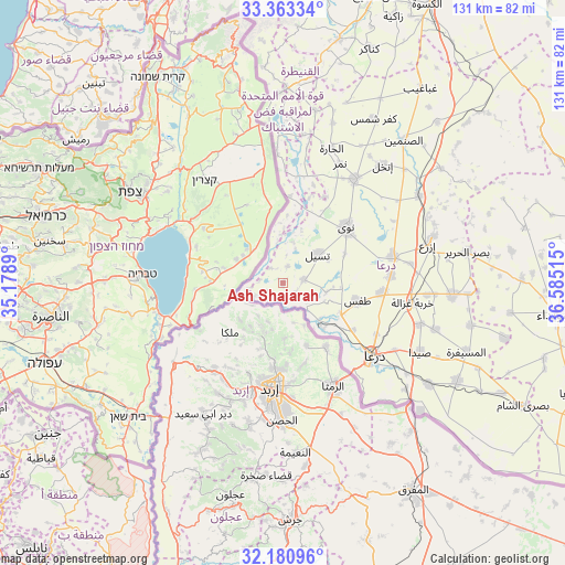
Ash Shajarah GPS coordinates[2]
32° 46' 26.796" North, 35° 52' 55.272" East
| Map corner | latitude | longitude |
|---|---|---|
| Upper-left | 33.36334°, | 35.1789° |
| Center: | 32.77411°, | 35.88202° |
| Lower-right: | 32.18096°, | 36.58515° |
| Map W x H: | 131.5×131.5 km | = 81.7×81.7mi |
| max Lat: | 37.17701° ⇑94.3% North |
| Ash Shajarah: | 32.77411° |
| min Lat: | ⇓5.7% South 32.39332° |
| min Long | Ash Shajarah | max Long |
| 35.75572° | 35.88202° | 42.14006° |
| W 1.8%⇐ | ⇒98.2% E |
Elevation
Elevation of Ash Shajarah is 419 m = 1375 ft, and this is 110.1 m = 361 ft below average elevation for this country.
| Max E: |
1640 m = 5381 ft | 58.3% |
| Avg. | 529.1 m = 1736 ft | |
| Ash Shajarah | 419 m = 1375 ft | |
Min E: |
4 m = 13 ft | 41.7% |
See also: Syria elevation on elevation.city.
Geographical zone
Ash Shajarah is located in North temperate zone (between Tropic of Cancer and the Arctic Circle). Distance of this Northern Tropic circle is 1038.2 km =645.1 mi to South.| Distance of | km | miles | from Ash Shajarah |
|---|---|---|---|
| North Pole | 6362.9 | 3953.7 | to North |
| Arctic Circle | 3757 | 2334.5 | to North |
| Tropic Cancer | 1038.2 | 645.1 | to South |
| Equator | 3644.1 | 2264.3 | to South |


Nearby cities:
15 places around Ash Shajarah: (largest is in red/bold)
• Al Muzayrīb
15.3 km =9.5 mi,  117°
117°
• Al Qunayţirah
39.5 km =24.5 mi,  352°
352°
• Al Ḩarāk
40.1 km =24.9 mi,  93°
93°
• Ash Shaykh Miskīn
26.6 km =16.5 mi,  76°
76°
• Aş Şanamayn
43.4 km =27 mi,  40°
40°
• Dar‘ā
26.9 km =16.7 mi,  129°
129°
• Dā‘il
23.2 km =14.4 mi,  95°
95°
• Inkhil
35.6 km =22.1 mi, 40°
• Izra‘
36.4 km =22.6 mi,  72°
72°
• Jāsim
29.4 km =18.3 mi,  34°
34°
• Khirbat Ghazālah
30.5 km =19 mi, 98°
• Khān Arnabah
45.6 km =28.3 mi,  1°
1°
• Nawá
19.6 km =12.2 mi,  48°
48°
• Tasīl
10.6 km =6.6 mi, 50°
• Ţafas
17.7 km =11 mi, 103°
Sources, notices
• [Note1] Compared only with cities in Syria existing in our database
• [Src1] Map data: © OpenStreetMap contributors (CC-BY-SA)
• [Src2] Other city data from geonames.org with taken over terms of usage.
• [Src3] Geographical zone / Annual Mean Temperature by Robert A. Rohde @ Wikipedia
