Izra‘ geodata
Izra‘ (Daraa) is a seat of a second-order administrative division; located in Syria in Asia/Damascus (GMT+3) time zone. With population of 13,882 people, there are 76 cities with bigger population in this country. Compared to other cities in Syria, 92.6% of cities are located further ↑North; 71.4% of cities are located further →East and 65.7% of cities have lower elevation than Izra‘. Note1


Izra‘ GPS coordinates[2]
32° 52' 14.16" North, 36° 15' 16.308" East
| Map corner | latitude | longitude |
|---|---|---|
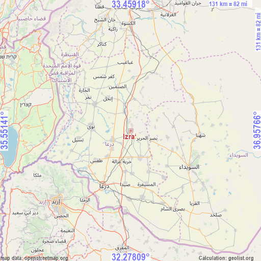
| Upper-left | 33.45918°, | 35.55141° |
| Center: | 32.8706°, | 36.25453° |
| Lower-right: | 32.27809°, | 36.95766° |
| Map W x H: | 131.3×131.3 km | = 81.6×81.6mi |
| max Lat: | 37.17701° ⇑92.6% North |
| Izra‘: | 32.8706° |
| min Lat: | ⇓7.4% South 32.39332° |
| min Long | Izra‘ | max Long |
| 35.75572° | 36.25453° | 42.14006° |
| W 28.6%⇐ | ⇒71.4% E |
Elevation
Elevation of Izra‘ is 581 m = 1906 ft, and this is 51.9 m = 170 ft above average elevation for this country.
| Max E: |
1640 m = 5381 ft | 34.3% |
| Izra‘ | 581 m 1906 ft | |
| Avg. | 529.1 m = 1736 ft | |
Min E: |
4 m = 13 ft | 65.7% |
See also: Syria elevation on elevation.city.
Geographical zone
Izra‘ is located in North temperate zone (between Tropic of Cancer and the Arctic Circle). Distance of this Northern Tropic circle is 1048.9 km =651.8 mi to South.| Distance of | km | miles | from Izra‘ |
|---|---|---|---|
| North Pole | 6352.2 | 3947.1 | to North |
| Arctic Circle | 3746.3 | 2327.8 | to North |
| Tropic Cancer | 1048.9 | 651.8 | to South |
| Equator | 3654.9 | 2271 | to South |


Nearby cities:
15 places around Izra‘: (largest is in red/bold)
• Al Mazra‘ah
22.9 km =14.2 mi,  114°
114°
• Al Musayfirah
27.7 km =17.2 mi,  163°
163°
• Al Muzayrīb
27.7 km =17.2 mi,  230°
230°
• Al Ḩarāk
14.4 km =8.9 mi, 158°
• Ash Shaykh Miskīn
10 km =6.2 mi,  242°
242°
• Aş Şanamayn
23.3 km =14.5 mi,  343°
343°
• Dā‘il
17.4 km =10.8 mi,  222°
222°
• Inkhil
20.2 km =12.6 mi,  324°
324°
• Jāsim
22.6 km =14 mi,  306°
306°
• Khirbat Ghazālah
15.9 km =9.9 mi,  197°
197°
• Nawá
20.2 km =12.6 mi,  276°
276°
• Tasīl
26.9 km =16.7 mi,  261°
261°
• Şalākhid
29.7 km =18.5 mi,  89°
89°
• Ţafas
23 km =14.3 mi, 229°
• ‘Arīqah
21.5 km =13.4 mi,  84°
84°
Sources, notices
• [Note1] Compared only with cities in Syria existing in our database
• [Src1] Map data: © OpenStreetMap contributors (CC-BY-SA)
• [Src2] Other city data from geonames.org with taken over terms of usage.
• [Src3] Geographical zone / Annual Mean Temperature by Robert A. Rohde @ Wikipedia
