Ghabāghib geodata
Ghabāghib (Daraa) is a seat of a third-order administrative division; located in Syria in Asia/Damascus (GMT+3) time zone. In our database, there are 87 cities with bigger population. Compared to other cities in Syria, 88.7% of cities are located further ↑North; 74.2% of cities are located further →East and 78.1% of cities have lower elevation than Ghabāghib. Note1


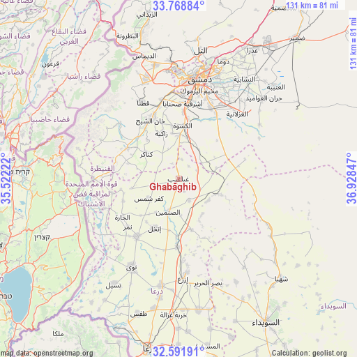
Ghabāghib GPS coordinates[2]
33° 10' 56.46" North, 36° 13' 31.224" East
| Map corner | latitude | longitude |
|---|---|---|
| Upper-left | 33.76884°, | 35.52222° |
| Center: | 33.18235°, | 36.22534° |
| Lower-right: | 32.59191°, | 36.92847° |
| Map W x H: | 130.9×130.9 km | = 81.3×81.3mi |
| max Lat: | 37.17701° ⇑88.7% North |
| Ghabāghib: | 33.18235° |
| min Lat: | ⇓11.3% South 32.39332° |
| min Long | Ghabāghib | max Long |
| 35.75572° | 36.22534° | 42.14006° |
| W 25.8%⇐ | ⇒74.2% E |
Elevation
Elevation of Ghabāghib is 698 m = 2290 ft, and this is 168.9 m = 554 ft above average elevation for this country.
| Max E: |
1640 m = 5381 ft | 21.9% |
| Ghabāghib | 698 m 2290 ft | |
| Avg. | 529.1 m = 1736 ft | |
Min E: |
4 m = 13 ft | 78.1% |
See also: Syria elevation on elevation.city.
Geographical zone
Ghabāghib is located in North temperate zone (between Tropic of Cancer and the Arctic Circle). Distance of this Northern Tropic circle is 1083.6 km =673.3 mi to South.| Distance of | km | miles | from Ghabāghib |
|---|---|---|---|
| North Pole | 6317.5 | 3925.5 | to North |
| Arctic Circle | 3711.6 | 2306.3 | to North |
| Tropic Cancer | 1083.6 | 673.3 | to South |
| Equator | 3689.5 | 2292.5 | to South |


Nearby cities:
15 places around Ghabāghib: (largest is in red/bold)
• Al Ghizlānīyah
32 km =19.9 mi,  41°
41°
• Al Kiswah
19.6 km =12.2 mi,  4°
4°
• Al Ḩajar al Aswad
31.5 km =19.6 mi,  13°
13°
• Aş Şanamayn
12.9 km =8 mi,  197°
197°
• Babīlā
33.6 km =20.9 mi,  16°
16°
• Dārayyā
30.7 km =19.1 mi, 1°
• Inkhil
20.4 km =12.7 mi,  206°
206°
• Izra‘
34.8 km =21.6 mi,  175°
175°
• Jāsim
26.1 km =16.2 mi,  216°
216°
• Khān Arnabah
31.1 km =19.3 mi,  270°
270°
• Mazra‘at Bayt Jinn
32.6 km =20.3 mi,  299°
299°
• Mismīyah
16.8 km =10.4 mi,  110°
110°
• Qaţanā
31.5 km =19.6 mi,  334°
334°
• Sahnaiya
27 km =16.8 mi, 0°
• Sa‘sa‘
22.1 km =13.7 mi, 300°
Sources, notices
• [Note1] Compared only with cities in Syria existing in our database
• [Src1] Map data: © OpenStreetMap contributors (CC-BY-SA)
• [Src2] Other city data from geonames.org with taken over terms of usage.
• [Src3] Geographical zone / Annual Mean Temperature by Robert A. Rohde @ Wikipedia
