‘Arīqah geodata
‘Arīqah (As-Suwayda) is a seat of a third-order administrative division; located in Syria in Asia/Damascus (GMT+3) time zone. In our database, there are 87 cities with bigger population. Compared to other cities in Syria, 91.9% of cities are located further ↑North; 56.9% of cities are located further →East and 84.5% of cities have lower elevation than ‘Arīqah. Note1


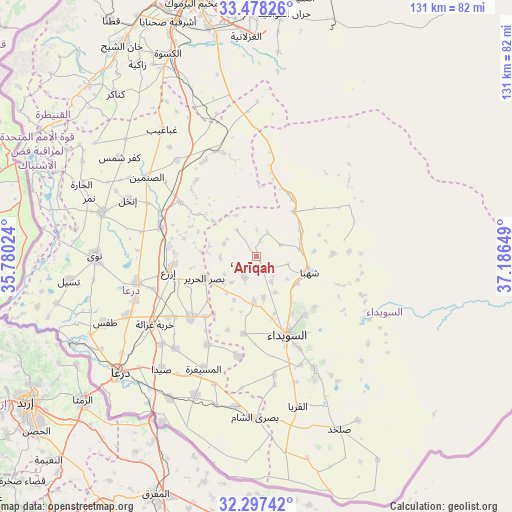
‘Arīqah GPS coordinates[2]
32° 53' 23.316" North, 36° 29' 0.096" East
| Map corner | latitude | longitude |
|---|---|---|
| Upper-left | 33.47826°, | 35.78024° |
| Center: | 32.88981°, | 36.48336° |
| Lower-right: | 32.29742°, | 37.18649° |
| Map W x H: | 131.3×131.3 km | = 81.6×81.6mi |
| max Lat: | 37.17701° ⇑91.9% North |
| ‘Arīqah: | 32.88981° |
| min Lat: | ⇓8.1% South 32.39332° |
| min Long | ‘Arīqah | max Long |
| 35.75572° | 36.48336° | 42.14006° |
| W 43.1%⇐ | ⇒56.9% E |
Elevation
Elevation of ‘Arīqah is 804 m = 2638 ft, and this is 274.9 m = 902 ft above average elevation for this country.
| Max E: |
1640 m = 5381 ft | 15.5% |
| ‘Arīqah | 804 m 2638 ft | |
| Avg. | 529.1 m = 1736 ft | |
Min E: |
4 m = 13 ft | 84.5% |
See also: Syria elevation on elevation.city.
Geographical zone
‘Arīqah is located in North temperate zone (between Tropic of Cancer and the Arctic Circle). Distance of this Northern Tropic circle is 1051.1 km =653.1 mi to South.| Distance of | km | miles | from ‘Arīqah |
|---|---|---|---|
| North Pole | 6350.1 | 3945.8 | to North |
| Arctic Circle | 3744.2 | 2326.5 | to North |
| Tropic Cancer | 1051.1 | 653.1 | to South |
| Equator | 3657 | 2272.4 | to South |


Nearby cities:
15 places around ‘Arīqah: (largest is in red/bold)
• Al Mazra‘ah
11.8 km =7.3 mi,  182°
182°
• Al Musayfirah
31.7 km =19.7 mi,  205°
205°
• Al Mushannaf
32 km =19.9 mi,  121°
121°
• Al Ḩarāk
22.5 km =14 mi,  226°
226°
• As-Suwayda
21.7 km =13.5 mi,  158°
158°
• Ash Shaykh Miskīn
31 km =19.3 mi,  257°
257°
• Aş Şanamayn
34.6 km =21.5 mi,  305°
305°
• Aş Şūrah aş Şaghīrah
18 km =11.2 mi,  28°
28°
• Inkhil
36.1 km =22.4 mi,  293°
293°
• Izra‘
21.5 km =13.4 mi, 264°
• Khirbat Ghazālah
31.3 km =19.4 mi,  236°
236°
• Mismīyah
27.9 km =17.3 mi,  342°
342°
• Shahbā
14.1 km =8.8 mi,  105°
105°
• Shaqqā
19.9 km =12.4 mi,  87°
87°
• Şalākhid
8.6 km =5.3 mi,  102°
102°
Sources, notices
• [Note1] Compared only with cities in Syria existing in our database
• [Src1] Map data: © OpenStreetMap contributors (CC-BY-SA)
• [Src2] Other city data from geonames.org with taken over terms of usage.
• [Src3] Geographical zone / Annual Mean Temperature by Robert A. Rohde @ Wikipedia
