As-Suwayda geodata
As-Suwayda is a seat of a first-order administrative division; located in Syria in Asia/Damascus (GMT+3) time zone. With population of 59,052 people, there are 20 cities with bigger population in this country. Compared to other cities in Syria, 96.8% of cities are located further ↑North; 51.6% of cities are located further →East and 92.9% of cities have lower elevation than As-Suwayda. Note1


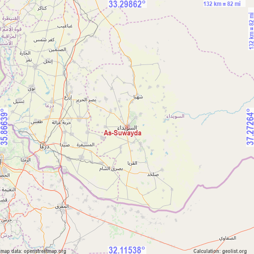
As-Suwayda GPS coordinates[2]
32° 42' 32.256" North, 36° 34' 10.236" East
| Map corner | latitude | longitude |
|---|---|---|
| Upper-left | 33.29862°, | 35.86639° |
| Center: | 32.70896°, | 36.56951° |
| Lower-right: | 32.11538°, | 37.27264° |
| Map W x H: | 131.6×131.6 km | = 81.8×81.8mi |
| max Lat: | 37.17701° ⇑96.8% North |
| As-Suwayda: | 32.70896° |
| min Lat: | ⇓3.2% South 32.39332° |
| min Long | As-Suwayda | max Long |
| 35.75572° | 36.56951° | 42.14006° |
| W 48.4%⇐ | ⇒51.6% E |
Elevation
Elevation of As-Suwayda is 1068 m = 3504 ft, and this is 538.9 m = 1768 ft above average elevation for this country.
| Max E: |
1640 m = 5381 ft | 7.1% |
| As-Suwayda | 1068 m 3504 ft | |
| Avg. | 529.1 m = 1736 ft | |
Min E: |
4 m = 13 ft | 92.9% |
See also: As-Suwayda elevation on elevation.city.
Geographical zone
As-Suwayda is located in North temperate zone (between Tropic of Cancer and the Arctic Circle). Distance of this Northern Tropic circle is 1031 km =640.6 mi to South.| Distance of | km | miles | from As-Suwayda |
|---|---|---|---|
| North Pole | 6370.2 | 3958.3 | to North |
| Arctic Circle | 3764.3 | 2339 | to North |
| Tropic Cancer | 1031 | 640.6 | to South |
| Equator | 3636.9 | 2259.9 | to South |


Nearby cities:
15 places around As-Suwayda: (largest is in red/bold)
• Al Jīzah
28.4 km =17.6 mi,  236°
236°
• Al Mazra‘ah
12 km =7.5 mi,  313°
313°
• Al Musayfirah
23.2 km =14.4 mi,  248°
248°
• Al Mushannaf
19.5 km =12.1 mi,  80°
80°
• Al Qurayyā
18.6 km =11.6 mi,  171°
171°
• Al Ḩarāk
24.7 km =15.3 mi,  280°
280°
• Buşrá ash Shām
22.5 km =14 mi,  201°
201°
• Dhībīn
30.1 km =18.7 mi,  180°
180°
• Izra‘
34.5 km =21.4 mi,  301°
301°
• Khirbat Ghazālah
34.3 km =21.3 mi,  274°
274°
• Shahbā
17.2 km =10.7 mi,  18°
18°
• Shaqqā
24.1 km =15 mi,  29°
29°
• Şalkhad
27.5 km =17.1 mi,  151°
151°
• Şalākhid
18.2 km =11.3 mi,  0°
0°
• ‘Arīqah
21.7 km =13.5 mi,  338°
338°
Sources, notices
• [Note1] Compared only with cities in Syria existing in our database
• [Src1] Map data: © OpenStreetMap contributors (CC-BY-SA)
• [Src2] Other city data from geonames.org with taken over terms of usage.
• [Src3] Geographical zone / Annual Mean Temperature by Robert A. Rohde @ Wikipedia
