Şalākhid geodata
Şalākhid (As-Suwayda) is a populated place; located in Syria in Asia/Damascus (GMT+3) time zone. With population of 12,842 people, there are 77 cities with bigger population in this country. Compared to other cities in Syria, 92.2% of cities are located further ↑North; 50.9% of cities are located further →East and 87.6% of cities have lower elevation than Şalākhid. Note1


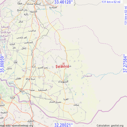
Şalākhid GPS coordinates[2]
32° 52' 21.756" North, 36° 34' 21.756" East
| Map corner | latitude | longitude |
|---|---|---|
| Upper-left | 33.46128°, | 35.86959° |
| Center: | 32.87271°, | 36.57271° |
| Lower-right: | 32.28021°, | 37.27584° |
| Map W x H: | 131.3×131.3 km | = 81.6×81.6mi |
| max Lat: | 37.17701° ⇑92.2% North |
| Şalākhid: | 32.87271° |
| min Lat: | ⇓7.8% South 32.39332° |
| min Long | Şalākhid | max Long |
| 35.75572° | 36.57271° | 42.14006° |
| W 49.1%⇐ | ⇒50.9% E |
Elevation
Elevation of Şalākhid is 885 m = 2904 ft, and this is 355.9 m = 1168 ft above average elevation for this country.
| Max E: |
1640 m = 5381 ft | 12.4% |
| Şalākhid | 885 m 2904 ft | |
| Avg. | 529.1 m = 1736 ft | |
Min E: |
4 m = 13 ft | 87.6% |
See also: Syria elevation on elevation.city.
Geographical zone
Şalākhid is located in North temperate zone (between Tropic of Cancer and the Arctic Circle). Distance of this Northern Tropic circle is 1049.2 km =651.9 mi to South.| Distance of | km | miles | from Şalākhid |
|---|---|---|---|
| North Pole | 6352 | 3946.9 | to North |
| Arctic Circle | 3746.1 | 2327.7 | to North |
| Tropic Cancer | 1049.2 | 651.9 | to South |
| Equator | 3655.1 | 2271.2 | to South |


Nearby cities:
15 places around Şalākhid: (largest is in red/bold)
• Al Mazra‘ah
13.3 km =8.3 mi,  222°
222°
• Al Musayfirah
34.5 km =21.4 mi, 219°
• Al Mushannaf
24 km =14.9 mi,  128°
128°
• Al Qurayyā
36.7 km =22.8 mi,  176°
176°
• Al Ḩarāk
28.1 km =17.5 mi,  240°
240°
• As-Suwayda
18.2 km =11.3 mi, 180°
• Ash Shaykh Miskīn
38.9 km =24.2 mi,  262°
262°
• Aş Şūrah aş Şaghīrah
17.8 km =11.1 mi,  0°
0°
• Buşrá ash Shām
40.1 km =24.9 mi,  192°
192°
• Izra‘
29.7 km =18.5 mi,  269°
269°
• Khirbat Ghazālah
37.7 km =23.4 mi,  245°
245°
• Mismīyah
33 km =20.5 mi,  329°
329°
• Shahbā
5.6 km =3.5 mi,  110°
110°
• Shaqqā
11.9 km =7.4 mi,  76°
76°
• ‘Arīqah
8.6 km =5.3 mi,  282°
282°
Sources, notices
• [Note1] Compared only with cities in Syria existing in our database
• [Src1] Map data: © OpenStreetMap contributors (CC-BY-SA)
• [Src2] Other city data from geonames.org with taken over terms of usage.
• [Src3] Geographical zone / Annual Mean Temperature by Robert A. Rohde @ Wikipedia
