Thanyaburi geodata
Thanyaburi (Pathum Thani) is a seat of a second-order administrative division; located in Thailand in Asia/Bangkok (GMT+7) time zone. In our database, there are 331 cities with bigger population. Compared to other cities in Thailand, 64.3% of cities are located further ↑North; 50.6% of cities are located further →East and 91.2% of cities have higher elevation than Thanyaburi. Note1


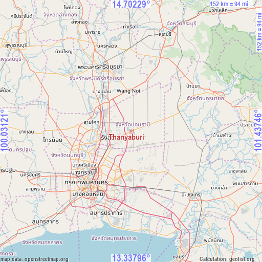
Thanyaburi GPS coordinates[2]
14° 1' 16.104" North, 100° 44' 3.588" East
| Map corner | latitude | longitude |
|---|---|---|
| Upper-left | 14.70229°, | 100.03121° |
| Center: | 14.02114°, | 100.73433° |
| Lower-right: | 13.33796°, | 101.43746° |
| Map W x H: | 151.7×151.7 km | = 94.3×94.3mi |
| max Lat: | 20.43353° ⇑64.3% North |
| Thanyaburi: | 14.02114° |
| min Lat: | ⇓35.7% South 5.77434° |
| min Long | Thanyaburi | max Long |
| 97.93288° | 100.73433° | 105.49506° |
| W 49.4%⇐ | ⇒50.6% E |
Elevation
Elevation of Thanyaburi is 8 m = 26 ft, and this is 117.5 m = 385 ft below average elevation for this country.
| Max E: |
1011 m = 3317 ft | 91.2% |
| Avg. | 125.5 m = 412 ft | |
| Thanyaburi | 8 m = 26 ft | |
Min E: |
1 m = 3 ft | 8.8% |
See also: Thailand elevation on elevation.city.
Geographical zone
Thanyaburi is located in North Torrid zone (between Equator and Tropic of Cancer). Distance of this Northern Tropic circle is 1046.9 km =650.5 mi to North.| Distance of | km | miles | from Thanyaburi |
|---|---|---|---|
| North Pole | 8448.1 | 5249.4 | to North |
| Arctic Circle | 5842.2 | 3630.2 | to North |
| Tropic Cancer | 1046.9 | 650.5 | to North |
| Equator | 1559 | 968.7 | to South |


Nearby cities:
15 places around Thanyaburi: (largest is in red/bold)
• Ban Bang Kadi Pathum Thani
20.1 km =12.5 mi,  262°
262°
• Ban Lam Luk Ka
6.8 km =4.2 mi,  136°
136°
• Bueng Kum
27.1 km =16.8 mi,  194°
194°
• Don Mueang
19.6 km =12.2 mi,  232°
232°
• Khan Na Yao
22.5 km =14 mi,  195°
195°
• Khlong Luang
10.7 km =6.6 mi,  296°
296°
• Khlong Sam Wa
20.6 km =12.8 mi,  179°
179°
• Lam Luk Ka
10 km =6.2 mi,  170°
170°
• Min Buri
23 km =14.3 mi, 180°
• Nong Chok
23 km =14.3 mi, 143°
• Nong Suea
16 km =9.9 mi,  37°
37°
• Pathum Thani
22 km =13.7 mi,  267°
267°
• Sai Mai
14.7 km =9.1 mi,  220°
220°
• Sam Khok
23.4 km =14.5 mi,  282°
282°
• Wang Noi
23 km =14.3 mi,  354°
354°
Sources, notices
• [Note1] Compared only with cities in Thailand existing in our database
• [Src1] Map data: © OpenStreetMap contributors (CC-BY-SA)
• [Src2] Other city data from geonames.org with taken over terms of usage.
• [Src3] Geographical zone / Annual Mean Temperature by Robert A. Rohde @ Wikipedia
