Khlong Luang geodata
Khlong Luang (Pathum Thani) is a seat of a second-order administrative division; located in Thailand in Asia/Bangkok (GMT+7) time zone. With population of 118,551 people, there are 16 cities with bigger population in this country. Compared to other cities in Thailand, 63.7% of cities are located further ↑North; 52.9% of cities are located further →East and 94.4% of cities have higher elevation than Khlong Luang. Note1


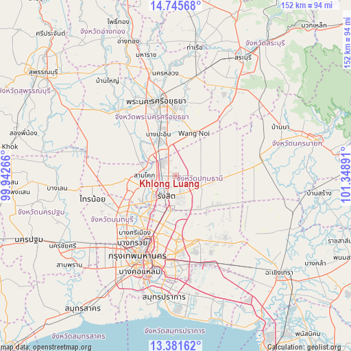
Khlong Luang GPS coordinates[2]
14° 3' 52.812" North, 100° 38' 44.808" East
| Map corner | latitude | longitude |
|---|---|---|
| Upper-left | 14.74568°, | 99.94266° |
| Center: | 14.06467°, | 100.64578° |
| Lower-right: | 13.38162°, | 101.34891° |
| Map W x H: | 151.7×151.7 km | = 94.3×94.3mi |
| max Lat: | 20.43353° ⇑63.7% North |
| Khlong Luang: | 14.06467° |
| min Lat: | ⇓36.3% South 5.77434° |
| min Long | Khlong Luang | max Long |
| 97.93288° | 100.64578° | 105.49506° |
| W 47.1%⇐ | ⇒52.9% E |
Elevation
Elevation of Khlong Luang is 7 m = 23 ft, and this is 118.5 m = 389 ft below average elevation for this country.
| Max E: |
1011 m = 3317 ft | 94.4% |
| Avg. | 125.5 m = 412 ft | |
| Khlong Luang | 7 m = 23 ft | |
Min E: |
1 m = 3 ft | 5.6% |
See also: Khlong Luang elevation on elevation.city.
Geographical zone
Khlong Luang is located in North Torrid zone (between Equator and Tropic of Cancer). Distance of this Northern Tropic circle is 1042.1 km =647.5 mi to North.| Distance of | km | miles | from Khlong Luang |
|---|---|---|---|
| North Pole | 8443.2 | 5246.4 | to North |
| Arctic Circle | 5837.3 | 3627.1 | to North |
| Tropic Cancer | 1042.1 | 647.5 | to North |
| Equator | 1563.8 | 971.7 | to South |


Nearby cities:
15 places around Khlong Luang: (largest is in red/bold)
• Ban Bang Kadi Pathum Thani
12.7 km =7.9 mi,  234°
234°
• Ban Lam Luk Ka
17.2 km =10.7 mi,  124°
124°
• Bang Pa-in
19.6 km =12.2 mi,  337°
337°
• Don Mueang
17.8 km =11.1 mi,  199°
199°
• Khan Na Yao
26.8 km =16.7 mi,  172°
172°
• Lam Luk Ka
18.5 km =11.5 mi,  142°
142°
• Lat Lum Kaeo
26.2 km =16.3 mi,  263°
263°
• Mueang Nonthaburi
26.7 km =16.6 mi,  211°
211°
• Nong Suea
20.8 km =12.9 mi,  68°
68°
• Pak Kret
23.1 km =14.4 mi,  223°
223°
• Pathum Thani
13.7 km =8.5 mi,  245°
245°
• Sai Mai
16 km =9.9 mi,  180°
180°
• Sam Khok
13.3 km =8.3 mi,  270°
270°
• Thanyaburi
10.7 km =6.6 mi, 116°
• Wang Noi
19.5 km =12.1 mi,  22°
22°
Sources, notices
• [Note1] Compared only with cities in Thailand existing in our database
• [Src1] Map data: © OpenStreetMap contributors (CC-BY-SA)
• [Src2] Other city data from geonames.org with taken over terms of usage.
• [Src3] Geographical zone / Annual Mean Temperature by Robert A. Rohde @ Wikipedia
